Moura elevation
Moura (Beja), Portugal elevation is 190 meters and Moura elevation in feet is 623 ft above sea level [src 1]. Moura is a seat of a second-order administrative division (feature code) with elevation that is 22 meters (72 ft) bigger than average city elevation in Portugal.
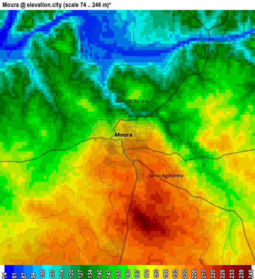
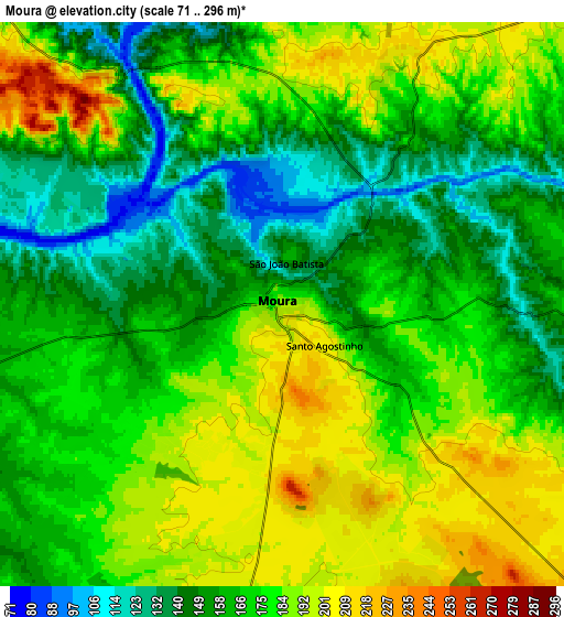
Below is the Elevation map of Moura, which displays elevation range with different colors. Scale of the first map is from 74 to 246 m (243 to 807 ft) with average elevation of 157.6 meters (=517 ft) [note 1]
These maps also provides idea of topography and contour of this city, they are displayed at different zoom levels. More info about maps, scale and edge coordinates you can find below images.
| \ | Map #1 | Map #2 | Topo.Map |
| Scale [m] | 74..246 m | 71..296 m | × |
| Scale [ft] | 243..807 ft | 233..971 ft | × |
| Average | 157.6 m = 517 ft | 170.7 m = 560 ft | × |
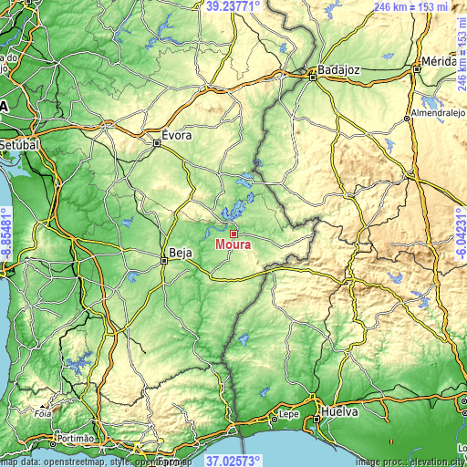
| Width | 7.69 km = 4.8 mi | 15.37 km = 9.6 mi | 245.9 km = 152.8 mi |
| Height | 7.69 km = 4.8 mi | 15.37 km = 9.6 mi | 245.9 km = 152.8 mi |
| ↑Max Latitude | 38.174655° | 38.209193° | 39.23771° |
| Latitude at center | 38.1401° | 38.1401° | 38.1401° |
| ↓Min Latitude | 38.105529° | 38.070941° | 37.02573° |
| ← Min Longitude | -7.492505° | -7.536451° | -8.85481° |
| Longitude center | -7.44856° | -7.44856° | -7.44856° |
| →Max Longitude | -7.404615° | -7.360669° | -6.04231° |
Nearby cities:
Cities around Moura sort by population:
• Beja elevation 286 m
38.9 km,  249°
249°
• Reguengos de Monsaraz 218 m
32.6 km,  346°
346°
• Serpa 198 m
25.2 km,  211°
211°
• Vidigueira 211 m
31.7 km,  284°
284°
• Cuba 180 m
38.9 km,  274°
274°
• Aldeia Nova de São Bento 250 m
24.1 km,  171°
171°
• Neves 164 m
34.5 km, 247°
• Cabeça Gorda 189 m
38.6 km,  231°
231°
• Salvada 183 m
36.3 km, 231°
• Barrancos 327 m
41.3 km,  90°
90°
• Portel 297 m
28.9 km,  309°
309°
• Mourão 178 m
28.6 km,  18°
18°
Multilingual:
 En español:
Moura elevación 190 m.
 En France:
Moura élévation 190 m.


Sources and notes:
- [note 1] Map square and city borders are not equal. Map elevation data is calculated only from area inside that square.
- [src 1] Elevation data from geonames database provided with same terms of usage.
- [src 2] The elevation map of Moura is generated using elevation data from NASA's 3 arcsec (90m) resolution SRTM data.
- [src 3] Base (background) map © OpenStreetMap contributors tiles are generated by Geofabrik and OpenTopoMap.
Copyright & License:
This Moura Elevation Map is licensed under CC BY-SA. You may reuse any part from this page, if you give a proper credit by linking to this URL:
 More info on terms of use page.