Nazaré elevation
Nazaré (Leiria), Portugal elevation is 46 meters and Nazaré elevation in feet is 151 ft above sea level [src 1]. Nazaré is a seat of a second-order administrative division (feature code) with elevation that is 122 meters (400 ft) smaller than average city elevation in Portugal.
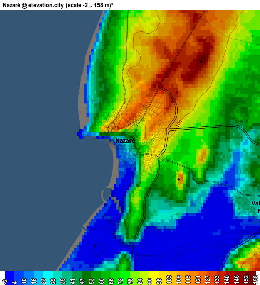
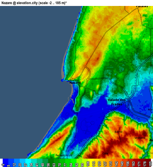
Below is the Elevation map of Nazaré, which displays elevation range with different colors. Scale of the first map is from -2 to 158 m (-7 to 518 ft) with average elevation of 60.4 meters (=198 ft) [note 1]
These maps also provides idea of topography and contour of this city, they are displayed at different zoom levels. More info about maps, scale and edge coordinates you can find below images.
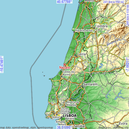
| \ | Map #1 | Map #2 | Topo.Map |
| Scale [m] | -2..158 m | -2..185 m | × |
| Scale [ft] | -7..518 ft | -7..607 ft | × |
| Average | 60.4 m = 198 ft | 75.3 m = 247 ft | × |
| Width | 7.53 km = 4.7 mi | 15.06 km = 9.4 mi | 240.9 km = 149.7 mi |
| Height | 7.53 km = 4.7 mi | 15.06 km = 9.4 mi | 240.9 km = 149.7 mi |
| ↑Max Latitude | 39.636741° | 39.670575° | 40.67788° |
| Latitude at center | 39.60289° | 39.60289° | 39.60289° |
| ↓Min Latitude | 39.569023° | 39.535139° | 38.51095° |
| ← Min Longitude | -9.112305° | -9.156251° | -10.47461° |
| Longitude center | -9.06836° | -9.06836° | -9.06836° |
| →Max Longitude | -9.024415° | -8.980469° | -7.66211° |
Nearby cities:
Cities around Nazaré sort by population:
• Alcobaça elevation 38 m
9.6 km,  125°
125°
• Maceira 164 m
17.7 km,  57°
57°
• Aljubarrota 183 m
12.6 km,  108°
108°
• Pataias 126 m
9.7 km,  39°
39°
• Turquel 201 m
17.3 km,  153°
153°
• Alfeizerão 22 m
11.9 km,  194°
194°
• Cela 181 m
7.5 km,  157°
157°
• Valado de Frades 23 m
4.4 km,  117°
117°
• São Martinho do Porto 13 m
11.2 km,  208°
208°
• Salir de Matos 47 m
19.2 km, 186°
• Famalicão 35 m
7.5 km, 189°
• Vestiaria 168 m
8.2 km, 132°
Multilingual:
 En español:
Nazaré elevación 46 m.
 En France:
Nazaré élévation 46 m.


Sources and notes:
- [note 1] Map square and city borders are not equal. Map elevation data is calculated only from area inside that square.
- [src 1] Elevation data from geonames database provided with same terms of usage.
- [src 2] The elevation map of Nazaré is generated using elevation data from NASA's 3 arcsec (90m) resolution SRTM data.
- [src 3] Base (background) map © OpenStreetMap contributors tiles are generated by Geofabrik and OpenTopoMap.
Copyright & License:
This Nazaré Elevation Map is licensed under CC BY-SA. You may reuse any part from this page, if you give a proper credit by linking to this URL:
 More info on terms of use page.