Ramada elevation
Ramada (Lisbon, Odivelas), Portugal elevation is 116 meters and Ramada elevation in feet is 381 ft above sea level [src 1]. Ramada is a populated place (feature code) with elevation that is 52 meters (171 ft) smaller than average city elevation in Portugal.
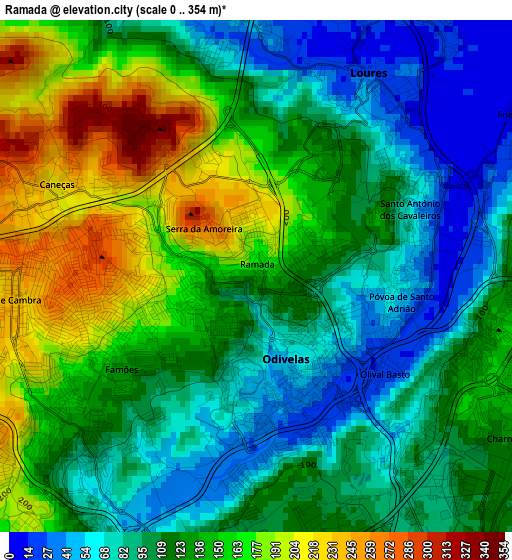
Below is the Elevation map of Ramada, which displays elevation range with different colors. Scale of the first map is from 0 to 354 m (0 to 1161 ft) with average elevation of 124.1 meters (=407 ft) [note 1]
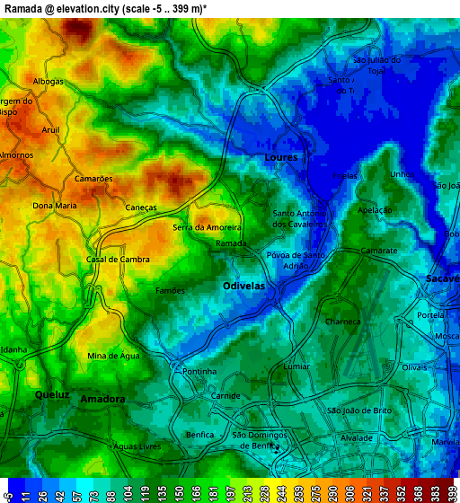
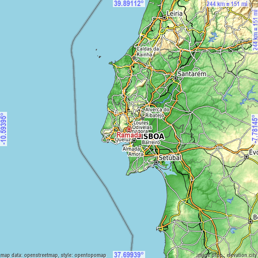
These maps also provides idea of topography and contour of this city, they are displayed at different zoom levels. More info about maps, scale and edge coordinates you can find below images.
| \ | Map #1 | Map #2 | Topo.Map |
| Scale [m] | 0..354 m | -5..399 m | × |
| Scale [ft] | 0..1161 ft | -16..1309 ft | × |
| Average | 124.1 m = 407 ft | 128.3 m = 421 ft | × |
| Width | 7.62 km = 4.7 mi | 15.23 km = 9.5 mi | 243.7 km = 151.4 mi |
| Height | 7.62 km = 4.7 mi | 15.23 km = 9.5 mi | 243.7 km = 151.4 mi |
| ↑Max Latitude | 38.837918° | 38.87214° | 39.89112° |
| Latitude at center | 38.80368° | 38.80368° | 38.80368° |
| ↓Min Latitude | 38.769425° | 38.735154° | 37.69939° |
| ← Min Longitude | -9.231645° | -9.275591° | -10.59395° |
| Longitude center | -9.1877° | -9.1877° | -9.1877° |
| →Max Longitude | -9.143755° | -9.099809° | -7.78145° |
Nearby cities:
Cities around Ramada sort by population:
• Loures elevation 23 m
3.5 km,  28°
28°
• Odivelas 50 m
1.3 km,  164°
164°
• Benfica 90 m
6 km,  192°
192°
• Pontinha 98 m
4.1 km, 194°
• Camarate 108 m
5.2 km,  90°
90°
• Póvoa de Santo Adrião 51 m
1.9 km,  102°
102°
• Caneças 234 m
3.5 km,  287°
287°
• Charneca 123 m
4.4 km,  120°
120°
• Famões 125 m
2.6 km,  228°
228°
• Apelação 89 m
4.9 km,  76°
76°
• Prior Velho 57 m
5.9 km, 102°
• Olival do Basto 22 m
2.3 km,  127°
127°
Multilingual:
 En español:
Ramada elevación 116 m.
 En France:
Ramada élévation 116 m.


Sources and notes:
- [note 1] Map square and city borders are not equal. Map elevation data is calculated only from area inside that square.
- [src 1] Elevation data from geonames database provided with same terms of usage.
- [src 2] The elevation map of Ramada is generated using elevation data from NASA's 3 arcsec (90m) resolution SRTM data.
- [src 3] Base (background) map © OpenStreetMap contributors tiles are generated by Geofabrik and OpenTopoMap.
Copyright & License:
This Ramada Elevation Map is licensed under CC BY-SA. You may reuse any part from this page, if you give a proper credit by linking to this URL:
 More info on terms of use page.