Senhora da Luz elevation
Senhora da Luz (Faro, Lagos), Portugal elevation is 4 meters and Senhora da Luz elevation in feet is 13 ft above sea level [src 1]. Senhora da Luz is a populated place (feature code) with elevation that is 164 meters (538 ft) smaller than average city elevation in Portugal.
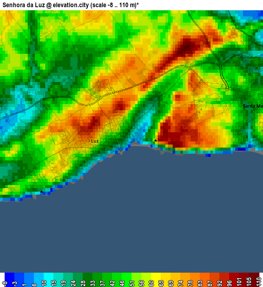
Below is the Elevation map of Senhora da Luz, which displays elevation range with different colors. Scale of the first map is from -8 to 110 m (-26 to 361 ft) with average elevation of 50.9 meters (=167 ft) [note 1]
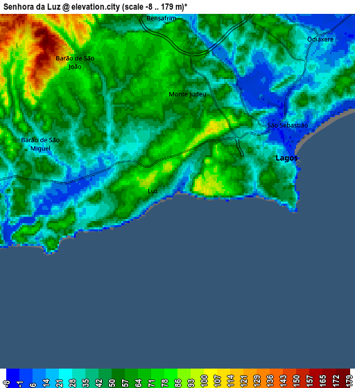
These maps also provides idea of topography and contour of this city, they are displayed at different zoom levels. More info about maps, scale and edge coordinates you can find below images.
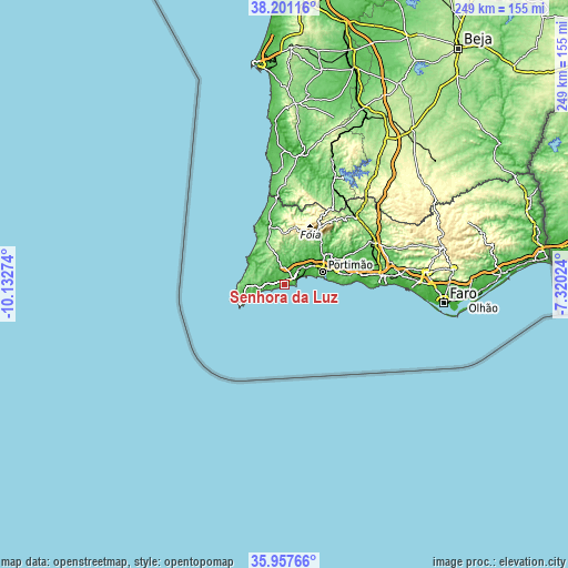
| \ | Map #1 | Map #2 | Topo.Map |
| Scale [m] | -8..110 m | -8..179 m | × |
| Scale [ft] | -26..361 ft | -26..587 ft | × |
| Average | 50.9 m = 167 ft | 49.6 m = 163 ft | × |
| Width | 7.8 km = 4.8 mi | 15.59 km = 9.7 mi | 249.5 km = 155 mi |
| Height | 7.8 km = 4.8 mi | 15.59 km = 9.7 mi | 249.5 km = 155 mi |
| ↑Max Latitude | 37.122758° | 37.157789° | 38.20116° |
| Latitude at center | 37.08771° | 37.08771° | 37.08771° |
| ↓Min Latitude | 37.052646° | 37.017566° | 35.95766° |
| ← Min Longitude | -8.770435° | -8.814381° | -10.13274° |
| Longitude center | -8.72649° | -8.72649° | -8.72649° |
| →Max Longitude | -8.682545° | -8.638599° | -7.32024° |
Nearby cities:
Cities around Senhora da Luz sort by population:
• Portimão elevation 13 m
17.7 km,  71°
71°
• Lagos 12 m
4.9 km, 71°
• Estômbar 29 m
22.4 km, 73°
• Lagoa 53 m
24.8 km,  77°
77°
• Alvor 16 m
12.8 km, 68°
• Mexilhoeira Grande 40 m
12.6 km,  51°
51°
• Parchal 9 m
19.4 km, 73°
• Carvoeiro 45 m
22.9 km,  87°
87°
• Bensafrim 33 m
7.6 km,  354°
354°
• Ferragudo 5 m
18.8 km, 77°
• Sagres 31 m
21.1 km,  245°
245°
• Vila do Bispo 81 m
16.4 km,  268°
268°
Multilingual:
 En español:
Senhora da Luz elevación 4 m.
 En France:
Senhora da Luz élévation 4 m.
 Auf Deutsch:
Senhora da Luz höhe über dem Meeresspiegel ist 4 m.

Sources and notes:
- [note 1] Map square and city borders are not equal. Map elevation data is calculated only from area inside that square.
- [src 1] Elevation data from geonames database provided with same terms of usage.
- [src 2] The elevation map of Senhora da Luz is generated using elevation data from NASA's 3 arcsec (90m) resolution SRTM data.
- [src 3] Base (background) map © OpenStreetMap contributors tiles are generated by Geofabrik and OpenTopoMap.
Copyright & License:
This Senhora da Luz Elevation Map is licensed under CC BY-SA. You may reuse any part from this page, if you give a proper credit by linking to this URL:
 More info on terms of use page.