Czernice Borowe elevation
Czernice Borowe (Mazovia, Powiat przasnyski), Poland elevation is 157 meters and Czernice Borowe elevation in feet is 515 ft above sea level [src 1]. Czernice Borowe is a seat of a third-order administrative division (feature code) with elevation that is 34 meters (112 ft) smaller than average city elevation in Poland.
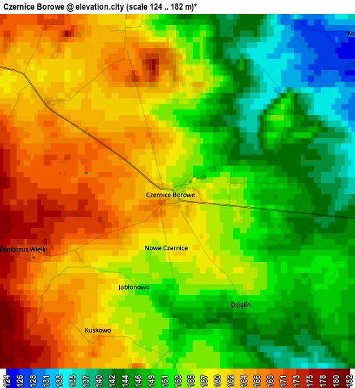
Below is the Elevation map of Czernice Borowe, which displays elevation range with different colors. Scale of the first map is from 124 to 182 m (407 to 597 ft) with average elevation of 155.2 meters (=509 ft) [note 1]
These maps also provides idea of topography and contour of this city, they are displayed at different zoom levels. More info about maps, scale and edge coordinates you can find below images.
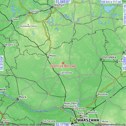
| \ | Map #1 | Topo.Map |
| Scale [m] | 124..182 m | × |
| Scale [ft] | 407..597 ft | × |
| Average | 155.2 m = 509 ft | × |
| Width | 5.88 km = 3.7 mi | 188.1 km = 116.9 mi |
| Height | 5.88 km = 3.7 mi | 188 km = 116.8 mi |
| ↑Max Latitude | 53.058389° | 53.86938° |
| Latitude at center | 53.03197° | 53.03197° |
| ↓Min Latitude | 53.005535° | 52.17798° |
| ← Min Longitude | 20.675495° | 19.31319° |
| Longitude center | 20.71944° | 20.71944° |
| →Max Longitude | 20.763385° | 22.12569° |
Nearby cities:
Cities around Czernice Borowe sort by population:
• Ciechanów elevation 119 m
18 km,  201°
201°
• Mława 149 m
24.1 km,  291°
291°
• Przasnysz 119 m
10.9 km,  97°
97°
• Grudusk 141 m
7 km, 294°
• Krasne 113 m
20.5 km,  125°
125°
• Stupsk 133 m
18.9 km,  266°
266°
• Dzierzgowo 148 m
13.9 km,  344°
344°
• Opinogóra Górna 147 m
14.1 km,  180°
180°
• Szydłowo 146 m
18.8 km, 286°
• Regimin 127 m
15 km,  227°
227°
• Krzynowłoga Mała 147 m
14.7 km,  17°
17°
• Płoniawy-Bramura 112 m
24.3 km, 104°
Multilingual:
 En español:
Czernice Borowe elevación 157 m.
 En France:
Czernice Borowe élévation 157 m.
 Auf Deutsch:
Czernice Borowe höhe über dem Meeresspiegel ist 157 m.

Sources and notes:
- [note 1] Map square and city borders are not equal. Map elevation data is calculated only from area inside that square.
- [src 1] Elevation data from geonames database provided with same terms of usage.
- [src 2] The elevation map of Czernice Borowe is generated using elevation data from NASA's 3 arcsec (90m) resolution SRTM data.
- [src 3] Base (background) map © OpenStreetMap contributors tiles are generated by Geofabrik and OpenTopoMap.
Copyright & License:
This Czernice Borowe Elevation Map is licensed under CC BY-SA. You may reuse any part from this page, if you give a proper credit by linking to this URL:
 More info on terms of use page.