Gołdap elevation
Gołdap (Warmia-Masuria, Powiat gołdapski), Poland elevation is 169 meters and Gołdap elevation in feet is 554 ft above sea level [src 1]. Gołdap is a populated place (feature code) with elevation that is 22 meters (72 ft) smaller than average city elevation in Poland.
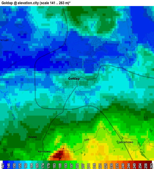
Below is the Elevation map of Gołdap, which displays elevation range with different colors. Scale of the first map is from 141 to 263 m (463 to 863 ft) with average elevation of 169.8 meters (=557 ft) [note 1]
These maps also provides idea of topography and contour of this city, they are displayed at different zoom levels. More info about maps, scale and edge coordinates you can find below images.
| \ | Map #1 | Map #2 | Topo.Map |
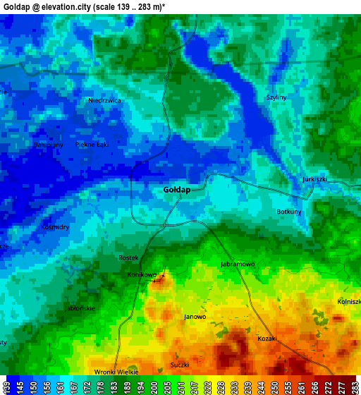
| Scale [m] | 141..263 m | 139..283 m | × |
| Scale [ft] | 463..863 ft | 456..928 ft | × |
| Average | 169.8 m = 557 ft | 181.5 m = 595 ft | × |
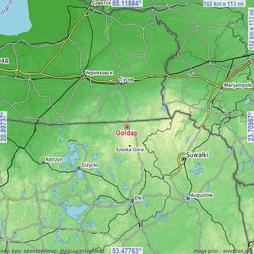
| Width | 5.7 km = 3.5 mi | 11.4 km = 7.1 mi | 182.5 km = 113.4 mi |
| Height | 5.7 km = 3.5 mi | 11.4 km = 7.1 mi | 182.4 km = 113.3 mi |
| ↑Max Latitude | 54.331942° | 54.357558° | 55.11864° |
| Latitude at center | 54.30631° | 54.30631° | 54.30631° |
| ↓Min Latitude | 54.280662° | 54.254998° | 53.47763° |
| ← Min Longitude | 22.259675° | 22.215729° | 20.89737° |
| Longitude center | 22.30362° | 22.30362° | 22.30362° |
| →Max Longitude | 22.347565° | 22.391511° | 23.70987° |
Nearby cities:
Cities around Gołdap sort by population:
• Suwałki elevation 177 m
46.2 km,  117°
117°
• Giżycko 120 m
46.1 km,  229°
229°
• Olecko 155 m
33.1 km,  156°
156°
• Węgorzewo 120 m
38.1 km,  254°
254°
• Wydminy 147 m
40.2 km,  206°
206°
• Filipów 182 m
24.9 km, 124°
• Kowale Oleckie 203 m
17.5 km, 155°
• Stare Juchy 136 m
43.6 km,  191°
191°
• Swiętajno 144 m
33.9 km,  178°
178°
• Banie Mazurskie 104 m
18.6 km, 249°
• Pozezdrze 135 m
34.2 km,  237°
237°
• Kruklanki 129 m
34.7 km, 225°
Multilingual:
 En español:
Gołdap elevación 169 m.
 En France:
Gołdap élévation 169 m.


Sources and notes:
- [note 1] Map square and city borders are not equal. Map elevation data is calculated only from area inside that square.
- [src 1] Elevation data from geonames database provided with same terms of usage.
- [src 2] The elevation map of Gołdap is generated using elevation data from NASA's 3 arcsec (90m) resolution SRTM data.
- [src 3] Base (background) map © OpenStreetMap contributors tiles are generated by Geofabrik and OpenTopoMap.
Copyright & License:
This Gołdap Elevation Map is licensed under CC BY-SA. You may reuse any part from this page, if you give a proper credit by linking to this URL:
 More info on terms of use page.