Grajewo elevation
Grajewo (Podlasie, Powiat grajewski), Poland elevation is 125 meters and Grajewo elevation in feet is 410 ft above sea level [src 1]. Grajewo is a seat of a second-order administrative division (feature code) with elevation that is 66 meters (217 ft) smaller than average city elevation in Poland.
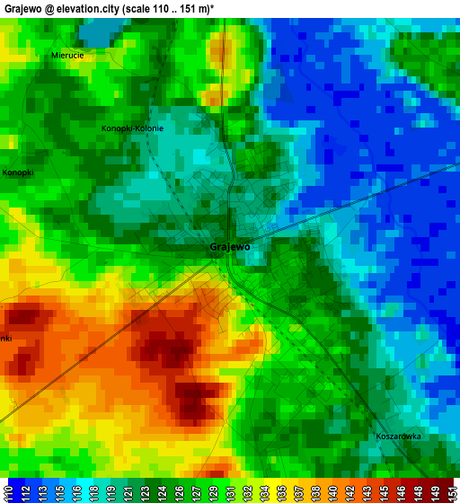
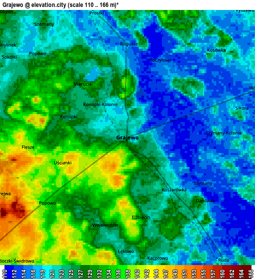
Below is the Elevation map of Grajewo, which displays elevation range with different colors. Scale of the first map is from 110 to 151 m (361 to 495 ft) with average elevation of 125.5 meters (=412 ft) [note 1]
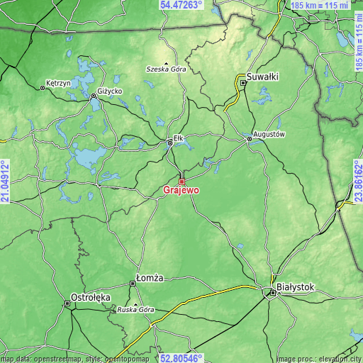
These maps also provides idea of topography and contour of this city, they are displayed at different zoom levels. More info about maps, scale and edge coordinates you can find below images.
| \ | Map #1 | Map #2 | Topo.Map |
| Scale [m] | 110..151 m | 110..166 m | × |
| Scale [ft] | 361..495 ft | 361..545 ft | × |
| Average | 125.5 m = 412 ft | 125.7 m = 412 ft | × |
| Width | 5.79 km = 3.6 mi | 11.59 km = 7.2 mi | 185.4 km = 115.2 mi |
| Height | 5.79 km = 3.6 mi | 11.59 km = 7.2 mi | 185.4 km = 115.2 mi |
| ↑Max Latitude | 53.673321° | 53.699345° | 54.47263° |
| Latitude at center | 53.64728° | 53.64728° | 53.64728° |
| ↓Min Latitude | 53.621223° | 53.59515° | 52.80546° |
| ← Min Longitude | 22.411425° | 22.367479° | 21.04912° |
| Longitude center | 22.45537° | 22.45537° | 22.45537° |
| →Max Longitude | 22.499315° | 22.543261° | 23.86162° |
Nearby cities:
Cities around Grajewo sort by population:
• Ełk elevation 127 m
21 km,  343°
343°
• Mońki 172 m
35.2 km,  139°
139°
• Orzysz 126 m
37.9 km,  298°
298°
• Biała Piska 138 m
26.2 km,  261°
261°
• Szczuczyn 128 m
14.6 km,  230°
230°
• Prostki 118 m
6 km, 344°
• Stawiski 144 m
35.8 km,  213°
213°
• Goniadz 134 m
25.5 km,  133°
133°
• Stare Juchy 136 m
35.7 km,  328°
328°
• Rajgród 121 m
18.9 km,  60°
60°
• Wąsosz 123 m
16.6 km, 212°
• Radziłów 119 m
26.6 km,  186°
186°
Multilingual:
 En español:
Grajewo elevación 125 m.
 En France:
Grajewo élévation 125 m.


Sources and notes:
- [note 1] Map square and city borders are not equal. Map elevation data is calculated only from area inside that square.
- [src 1] Elevation data from geonames database provided with same terms of usage.
- [src 2] The elevation map of Grajewo is generated using elevation data from NASA's 3 arcsec (90m) resolution SRTM data.
- [src 3] Base (background) map © OpenStreetMap contributors tiles are generated by Geofabrik and OpenTopoMap.
Copyright & License:
This Grajewo Elevation Map is licensed under CC BY-SA. You may reuse any part from this page, if you give a proper credit by linking to this URL:
 More info on terms of use page.