Kije elevation
Kije (Świętokrzyskie, Powiat pińczowski), Poland elevation is 234 meters and Kije elevation in feet is 768 ft above sea level [src 1]. Kije is a seat of a third-order administrative division (feature code) with elevation that is 43 meters (141 ft) bigger than average city elevation in Poland.
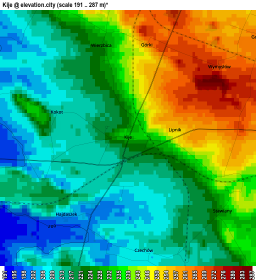
Below is the Elevation map of Kije, which displays elevation range with different colors. Scale of the first map is from 191 to 287 m (627 to 942 ft) with average elevation of 227.6 meters (=747 ft) [note 1]
These maps also provides idea of topography and contour of this city, they are displayed at different zoom levels. More info about maps, scale and edge coordinates you can find below images.
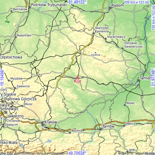
| \ | Map #1 | Topo.Map |
| Scale [m] | 191..287 m | × |
| Scale [ft] | 627..942 ft | × |
| Average | 227.6 m = 747 ft | × |
| Width | 6.2 km = 3.9 mi | 198.5 km = 123.3 mi |
| Height | 6.2 km = 3.9 mi | 198.5 km = 123.3 mi |
| ↑Max Latitude | 50.635091° | 51.49122° |
| Latitude at center | 50.60721° | 50.60721° |
| ↓Min Latitude | 50.579313° | 49.70628° |
| ← Min Longitude | 20.527265° | 19.16496° |
| Longitude center | 20.57121° | 20.57121° |
| →Max Longitude | 20.615155° | 21.97746° |
Nearby cities:
Cities around Kije sort by population:
• Busko-Zdrój elevation 266 m
18.4 km,  145°
145°
• Jędrzejów 242 m
19.1 km,  280°
280°
• Pińczów 204 m
10.1 km,  198°
198°
• Chęciny 279 m
22.8 km,  340°
340°
• Chmielnik 239 m
12.8 km,  86°
86°
• Brzeziny 243 m
18.4 km,  0°
0°
• Morawica 226 m
15.9 km,  11°
11°
• Michałów 192 m
14.6 km,  211°
211°
• Pierzchnica 274 m
16.4 km,  52°
52°
• Sobków 205 m
13.4 km,  320°
320°
• Gnojno 236 m
19.6 km, 91°
• Imielno 213 m
9 km,  254°
254°
Multilingual:
 En español:
Kije elevación 234 m.
 En France:
Kije élévation 234 m.


Sources and notes:
- [note 1] Map square and city borders are not equal. Map elevation data is calculated only from area inside that square.
- [src 1] Elevation data from geonames database provided with same terms of usage.
- [src 2] The elevation map of Kije is generated using elevation data from NASA's 3 arcsec (90m) resolution SRTM data.
- [src 3] Base (background) map © OpenStreetMap contributors tiles are generated by Geofabrik and OpenTopoMap.
Copyright & License:
This Kije Elevation Map is licensed under CC BY-SA. You may reuse any part from this page, if you give a proper credit by linking to this URL:
 More info on terms of use page.