Klimontów elevation
Klimontów (Lesser Poland, Powiat proszowicki), Poland elevation is 224 meters and Klimontów elevation in feet is 735 ft above sea level [src 1]. Klimontów is a populated place (feature code) with elevation that is 33 meters (108 ft) bigger than average city elevation in Poland.
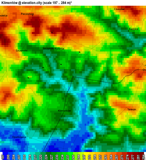
Below is the Elevation map of Klimontów, which displays elevation range with different colors. Scale of the first map is from 197 to 284 m (646 to 932 ft) with average elevation of 236.4 meters (=776 ft) [note 1]
These maps also provides idea of topography and contour of this city, they are displayed at different zoom levels. More info about maps, scale and edge coordinates you can find below images.
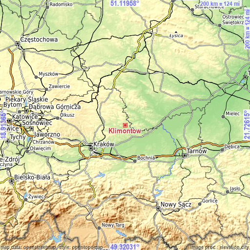
| \ | Map #1 | Topo.Map |
| Scale [m] | 197..284 m | × |
| Scale [ft] | 646..932 ft | × |
| Average | 236.4 m = 776 ft | × |
| Width | 6.25 km = 3.9 mi | 200.1 km = 124.3 mi |
| Height | 6.25 km = 3.9 mi | 200 km = 124.3 mi |
| ↑Max Latitude | 50.256535° | 51.11958° |
| Latitude at center | 50.22843° | 50.22843° |
| ↓Min Latitude | 50.200309° | 49.32031° |
| ← Min Longitude | 20.275955° | 18.91365° |
| Longitude center | 20.3199° | 20.3199° |
| →Max Longitude | 20.363845° | 21.72615° |
Nearby cities:
Cities around Klimontów sort by population:
• Proszowice elevation 222 m
4.5 km,  208°
208°
• Kazimierza Wielka 189 m
13 km,  71°
71°
• Słomniki 251 m
17 km,  274°
274°
• Wawrzeńczyce 198 m
13.2 km,  181°
181°
• Nowe Brzesko 199 m
11.4 km,  159°
159°
• Zabierzów Bocheński 186 m
17.8 km, 180°
• Skalbmierz 199 m
11.6 km,  29°
29°
• Wola Zabierzowska 187 m
17.4 km, 177°
• Dziewin 186 m
19.5 km,  150°
150°
• Działoszyce 213 m
15.4 km,  8°
8°
• Bejsce 183 m
19.8 km,  86°
86°
• Czarnocin 229 m
18.7 km,  48°
48°
Multilingual:
 En español:
Klimontów elevación 224 m.
 En France:
Klimontów élévation 224 m.
 Auf Deutsch:
Klimontów höhe über dem Meeresspiegel ist 224 m.

Sources and notes:
- [note 1] Map square and city borders are not equal. Map elevation data is calculated only from area inside that square.
- [src 1] Elevation data from geonames database provided with same terms of usage.
- [src 2] The elevation map of Klimontów is generated using elevation data from NASA's 3 arcsec (90m) resolution SRTM data.
- [src 3] Base (background) map © OpenStreetMap contributors tiles are generated by Geofabrik and OpenTopoMap.
Copyright & License:
This Klimontów Elevation Map is licensed under CC BY-SA. You may reuse any part from this page, if you give a proper credit by linking to this URL:
 More info on terms of use page.