Korzenna elevation
Korzenna (Lesser Poland, Powiat nowosądecki), Poland elevation is 348 meters and Korzenna elevation in feet is 1142 ft above sea level [src 1]. Korzenna is a populated place (feature code) with elevation that is 157 meters (515 ft) bigger than average city elevation in Poland.
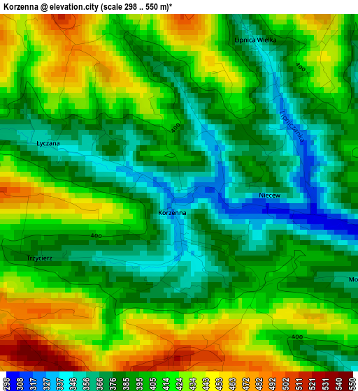
Below is the Elevation map of Korzenna, which displays elevation range with different colors. Scale of the first map is from 298 to 550 m (978 to 1804 ft) with average elevation of 403.2 meters (=1323 ft) [note 1]
These maps also provides idea of topography and contour of this city, they are displayed at different zoom levels. More info about maps, scale and edge coordinates you can find below images.
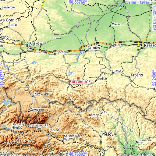
| \ | Map #1 | Topo.Map |
| Scale [m] | 298..550 m | × |
| Scale [ft] | 978..1804 ft | × |
| Average | 403.2 m = 1323 ft | × |
| Width | 6.32 km = 3.9 mi | 202.3 km = 125.7 mi |
| Height | 6.32 km = 3.9 mi | 202.3 km = 125.7 mi |
| ↑Max Latitude | 49.714773° | 50.58766° |
| Latitude at center | 49.68635° | 49.68635° |
| ↓Min Latitude | 49.65791° | 48.76802° |
| ← Min Longitude | 20.799605° | 19.4373° |
| Longitude center | 20.84355° | 20.84355° |
| →Max Longitude | 20.887495° | 22.2498° |
Nearby cities:
Cities around Korzenna sort by population:
• Nowy Sącz elevation 293 m
12.8 km,  235°
235°
• Grybów 329 m
10.2 km,  132°
132°
• Łososina Dolna 246 m
16.8 km,  294°
294°
• Łużna 300 m
14.9 km,  78°
78°
• Bobowa 285 m
7.9 km,  71°
71°
• Kamionka Wielka 447 m
13.2 km,  186°
186°
• Nawojowa 347 m
15.3 km,  209°
209°
• Chełmiec 281 m
14.3 km, 244°
• Ciężkowice 280 m
14.5 km,  40°
40°
• Lipnica Wielka 354 m
2.7 km, 40°
• Jastrzębia 311 m
12.6 km,  12°
12°
• Bystra 405 m
17.7 km,  98°
98°
Multilingual:
 En español:
Korzenna elevación 348 m.
 En France:
Korzenna élévation 348 m.
 Auf Deutsch:
Korzenna höhe über dem Meeresspiegel ist 348 m.

Sources and notes:
- [note 1] Map square and city borders are not equal. Map elevation data is calculated only from area inside that square.
- [src 1] Elevation data from geonames database provided with same terms of usage.
- [src 2] The elevation map of Korzenna is generated using elevation data from NASA's 3 arcsec (90m) resolution SRTM data.
- [src 3] Base (background) map © OpenStreetMap contributors tiles are generated by Geofabrik and OpenTopoMap.
Copyright & License:
This Korzenna Elevation Map is licensed under CC BY-SA. You may reuse any part from this page, if you give a proper credit by linking to this URL:
 More info on terms of use page.