Łapy elevation
Łapy (Podlasie, Powiat białostocki), Poland elevation is 120 meters and Łapy elevation in feet is 394 ft above sea level [src 1]. Łapy is a seat of a third-order administrative division (feature code) with elevation that is 71 meters (233 ft) smaller than average city elevation in Poland.
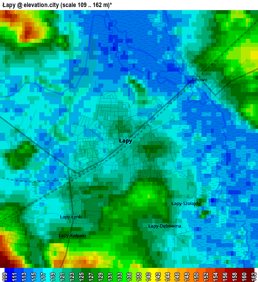
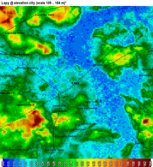
Below is the Elevation map of Łapy, which displays elevation range with different colors. Scale of the first map is from 109 to 162 m (358 to 531 ft) with average elevation of 121.8 meters (=400 ft) [note 1]
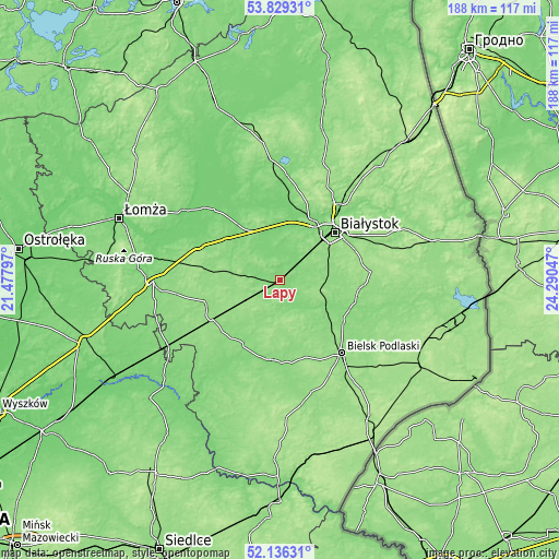
These maps also provides idea of topography and contour of this city, they are displayed at different zoom levels. More info about maps, scale and edge coordinates you can find below images.
| \ | Map #1 | Map #2 | Topo.Map |
| Scale [m] | 109..162 m | 109..164 m | × |
| Scale [ft] | 358..531 ft | 358..538 ft | × |
| Average | 121.8 m = 400 ft | 125.2 m = 411 ft | × |
| Width | 5.88 km = 3.7 mi | 11.76 km = 7.3 mi | 188.2 km = 116.9 mi |
| Height | 5.88 km = 3.7 mi | 11.76 km = 7.3 mi | 188.2 km = 116.9 mi |
| ↑Max Latitude | 53.017544° | 53.043972° | 53.82931° |
| Latitude at center | 52.9911° | 52.9911° | 52.9911° |
| ↓Min Latitude | 52.964639° | 52.938163° | 52.13631° |
| ← Min Longitude | 22.840275° | 22.796329° | 21.47797° |
| Longitude center | 22.88422° | 22.88422° | 22.88422° |
| →Max Longitude | 22.928165° | 22.972111° | 24.29047° |
Nearby cities:
Cities around Łapy sort by population:
• Białystok elevation 135 m
24.5 km,  49°
49°
• Wysokie Mazowieckie 143 m
25.9 km,  251°
251°
• Choroszcz 125 m
18.3 km,  22°
22°
• Brańsk 130 m
27.6 km,  186°
186°
• Zabłudów 153 m
30.5 km,  85°
85°
• Szepietowo 148 m
26.5 km,  239°
239°
• Tykocin 110 m
25 km,  342°
342°
• Sokoły 151 m
12.3 km,  271°
271°
• Dobrzyniewo Duże 124 m
24.8 km, 20°
• Suraż 123 m
6.7 km,  133°
133°
• Turośń Kościelna 129 m
11.7 km,  77°
77°
• Wyszki 145 m
17.9 km,  158°
158°
Multilingual:
 En español:
Łapy elevación 120 m.
 En France:
Łapy élévation 120 m.


Sources and notes:
- [note 1] Map square and city borders are not equal. Map elevation data is calculated only from area inside that square.
- [src 1] Elevation data from geonames database provided with same terms of usage.
- [src 2] The elevation map of Łapy is generated using elevation data from NASA's 3 arcsec (90m) resolution SRTM data.
- [src 3] Base (background) map © OpenStreetMap contributors tiles are generated by Geofabrik and OpenTopoMap.
Copyright & License:
This Łapy Elevation Map is licensed under CC BY-SA. You may reuse any part from this page, if you give a proper credit by linking to this URL:
 More info on terms of use page.