Łaziska elevation
Łaziska (Lublin, Powiat opolski), Poland elevation is 136 meters and Łaziska elevation in feet is 446 ft above sea level [src 1]. Łaziska is a seat of a third-order administrative division (feature code) with elevation that is 55 meters (180 ft) smaller than average city elevation in Poland.
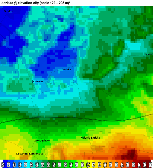
Below is the Elevation map of Łaziska, which displays elevation range with different colors. Scale of the first map is from 122 to 208 m (400 to 682 ft) with average elevation of 149.2 meters (=490 ft) [note 1]
These maps also provides idea of topography and contour of this city, they are displayed at different zoom levels. More info about maps, scale and edge coordinates you can find below images.
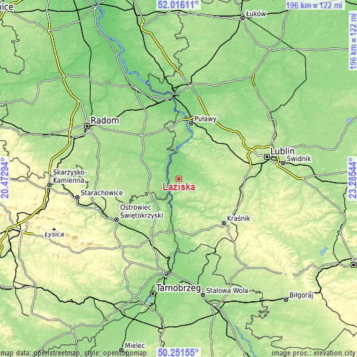
| \ | Map #1 | Topo.Map |
| Scale [m] | 122..208 m | × |
| Scale [ft] | 400..682 ft | × |
| Average | 149.2 m = 490 ft | × |
| Width | 6.13 km = 3.8 mi | 196.2 km = 121.9 mi |
| Height | 6.13 km = 3.8 mi | 196.2 km = 121.9 mi |
| ↑Max Latitude | 51.169823° | 52.01611° |
| Latitude at center | 51.14226° | 51.14226° |
| ↓Min Latitude | 51.114681° | 50.25155° |
| ← Min Longitude | 21.835245° | 20.47294° |
| Longitude center | 21.87919° | 21.87919° |
| →Max Longitude | 21.923135° | 23.28544° |
Nearby cities:
Cities around Łaziska sort by population:
• Poniatowa elevation 206 m
18 km,  76°
76°
• Opole Lubelskie 150 m
6.3 km, 84°
• Lipsko 162 m
16.1 km,  276°
276°
• Kazimierz Dolny 132 m
20.4 km,  15°
15°
• Solec Nad Wisłą 156 m
7.9 km,  265°
265°
• Chodel 166 m
18 km,  100°
100°
• Józefów nad Wisłą 147 m
11.7 km,  197°
197°
• Janowiec 125 m
20.2 km,  2°
2°
• Karczmiska 169 m
12 km,  36°
36°
• Tarłów 161 m
19.4 km,  216°
216°
• Chotcza 127 m
13 km,  326°
326°
• Wilków 122 m
13.3 km,  359°
359°
Multilingual:
 En español:
Łaziska elevación 136 m.
 En France:
Łaziska élévation 136 m.


Sources and notes:
- [note 1] Map square and city borders are not equal. Map elevation data is calculated only from area inside that square.
- [src 1] Elevation data from geonames database provided with same terms of usage.
- [src 2] The elevation map of Łaziska is generated using elevation data from NASA's 3 arcsec (90m) resolution SRTM data.
- [src 3] Base (background) map © OpenStreetMap contributors tiles are generated by Geofabrik and OpenTopoMap.
Copyright & License:
This Łaziska Elevation Map is licensed under CC BY-SA. You may reuse any part from this page, if you give a proper credit by linking to this URL:
 More info on terms of use page.