Lutoryż elevation
Lutoryż (Subcarpathian, Powiat rzeszowski), Poland elevation is 227 meters and Lutoryż elevation in feet is 745 ft above sea level [src 1]. Lutoryż is a populated place (feature code) with elevation that is 36 meters (118 ft) bigger than average city elevation in Poland.
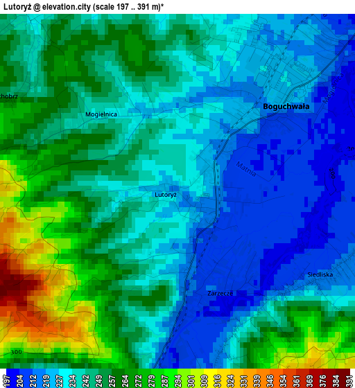
Below is the Elevation map of Lutoryż, which displays elevation range with different colors. Scale of the first map is from 197 to 391 m (646 to 1283 ft) with average elevation of 243.6 meters (=799 ft) [note 1]
These maps also provides idea of topography and contour of this city, they are displayed at different zoom levels. More info about maps, scale and edge coordinates you can find below images.
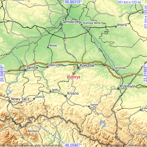
| \ | Map #1 | Topo.Map |
| Scale [m] | 197..391 m | × |
| Scale [ft] | 646..1283 ft | × |
| Average | 243.6 m = 799 ft | × |
| Width | 6.29 km = 3.9 mi | 201.2 km = 125 mi |
| Height | 6.29 km = 3.9 mi | 201.1 km = 125 mi |
| ↑Max Latitude | 49.995379° | 50.86318° |
| Latitude at center | 49.96712° | 49.96712° |
| ↓Min Latitude | 49.938845° | 49.05407° |
| ← Min Longitude | 21.868455° | 20.50615° |
| Longitude center | 21.9124° | 21.9124° |
| →Max Longitude | 21.956345° | 23.31865° |
Nearby cities:
Cities around Lutoryż sort by population:
• Boguchwała elevation 222 m
3.1 km,  50°
50°
• Tyczyn 228 m
8.7 km,  92°
92°
• Czudec 228 m
5.7 km,  244°
244°
• Niechobrz 229 m
3.9 km,  321°
321°
• Lubenia 245 m
4.2 km,  165°
165°
• Straszydle 257 m
8.9 km,  146°
146°
• Przybyszówka 227 m
9 km,  6°
6°
• Połomia 306 m
7.1 km,  191°
191°
• Siedliska 210 m
2.9 km,  120°
120°
• Zgłobień 231 m
6.5 km, 320°
• Babica 220 m
4.7 km,  219°
219°
• Kielanówka 287 m
6.7 km, 10°
Multilingual:
 En español:
Lutoryż elevación 227 m.
 En France:
Lutoryż élévation 227 m.


Sources and notes:
- [note 1] Map square and city borders are not equal. Map elevation data is calculated only from area inside that square.
- [src 1] Elevation data from geonames database provided with same terms of usage.
- [src 2] The elevation map of Lutoryż is generated using elevation data from NASA's 3 arcsec (90m) resolution SRTM data.
- [src 3] Base (background) map © OpenStreetMap contributors tiles are generated by Geofabrik and OpenTopoMap.
Copyright & License:
This Lutoryż Elevation Map is licensed under CC BY-SA. You may reuse any part from this page, if you give a proper credit by linking to this URL:
 More info on terms of use page.