Michałów elevation
Michałów (Lublin, Powiat zamojski), Poland elevation is 210 meters and Michałów elevation in feet is 689 ft above sea level [src 1]. Michałów is a populated place (feature code) with elevation that is 19 meters (62 ft) bigger than average city elevation in Poland.
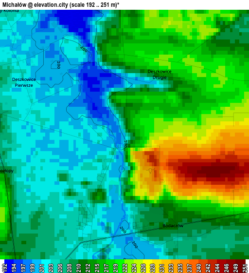
Below is the Elevation map of Michałów, which displays elevation range with different colors. Scale of the first map is from 192 to 251 m (630 to 823 ft) with average elevation of 211.6 meters (=694 ft) [note 1]
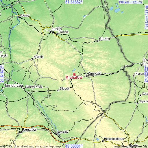
These maps also provides idea of topography and contour of this city, they are displayed at different zoom levels. More info about maps, scale and edge coordinates you can find below images.
| \ | Map #1 | Topo.Map |
| Scale [m] | 192..251 m | × |
| Scale [ft] | 630..823 ft | × |
| Average | 211.6 m = 694 ft | × |
| Width | 6.18 km = 3.8 mi | 197.9 km = 123 mi |
| Height | 6.18 km = 3.8 mi | 197.9 km = 123 mi |
| ↑Max Latitude | 50.765074° | 51.61882° |
| Latitude at center | 50.73727° | 50.73727° |
| ↓Min Latitude | 50.70945° | 49.83881° |
| ← Min Longitude | 22.979025° | 21.61672° |
| Longitude center | 23.02297° | 23.02297° |
| →Max Longitude | 23.066915° | 24.42922° |
Nearby cities:
Cities around Michałów sort by population:
• Zamość elevation 213 m
16.2 km,  95°
95°
• Szczebrzeszyn 214 m
5.6 km,  213°
213°
• Zwierzyniec 225 m
14.1 km,  193°
193°
• Izbica 186 m
19 km,  28°
28°
• Tereszpol 255 m
19.8 km, 210°
• Turobin 215 m
21.9 km,  295°
295°
• Radecznica 205 m
13.7 km,  276°
276°
• Nielisz 207 m
7.2 km,  12°
12°
• Żółkiewka 225 m
23.3 km,  325°
325°
• Stary Zamość 204 m
13.9 km,  48°
48°
• Rudnik 228 m
16.3 km,  347°
347°
• Sułów 203 m
6 km,  308°
308°
Multilingual:
 En español:
Michałów elevación 210 m.
 En France:
Michałów élévation 210 m.
 Auf Deutsch:
Michałów höhe über dem Meeresspiegel ist 210 m.

Sources and notes:
- [note 1] Map square and city borders are not equal. Map elevation data is calculated only from area inside that square.
- [src 1] Elevation data from geonames database provided with same terms of usage.
- [src 2] The elevation map of Michałów is generated using elevation data from NASA's 3 arcsec (90m) resolution SRTM data.
- [src 3] Base (background) map © OpenStreetMap contributors tiles are generated by Geofabrik and OpenTopoMap.
Copyright & License:
This Michałów Elevation Map is licensed under CC BY-SA. You may reuse any part from this page, if you give a proper credit by linking to this URL:
 More info on terms of use page.