Ostrowsko elevation
Ostrowsko (Lesser Poland, Powiat nowotarski), Poland elevation is 568 meters and Ostrowsko elevation in feet is 1864 ft above sea level [src 1]. Ostrowsko is a populated place (feature code) with elevation that is 377 meters (1237 ft) bigger than average city elevation in Poland.
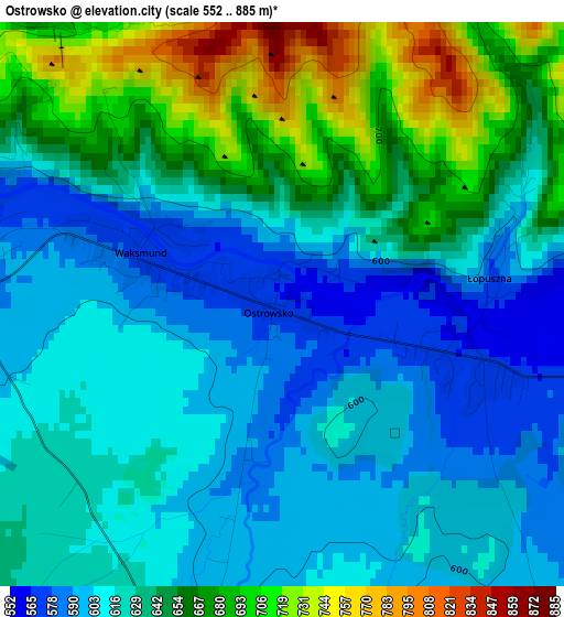
Below is the Elevation map of Ostrowsko, which displays elevation range with different colors. Scale of the first map is from 552 to 885 m (1811 to 2904 ft) with average elevation of 634 meters (=2080 ft) [note 1]
These maps also provides idea of topography and contour of this city, they are displayed at different zoom levels. More info about maps, scale and edge coordinates you can find below images.
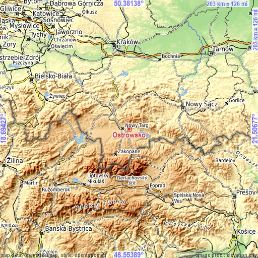
| \ | Map #1 | Topo.Map |
| Scale [m] | 552..885 m | × |
| Scale [ft] | 1811..2904 ft | × |
| Average | 634 m = 2080 ft | × |
| Width | 6.35 km = 3.9 mi | 203.2 km = 126.3 mi |
| Height | 6.35 km = 3.9 mi | 203.2 km = 126.3 mi |
| ↑Max Latitude | 49.504706° | 50.38138° |
| Latitude at center | 49.47616° | 49.47616° |
| ↓Min Latitude | 49.447598° | 48.55389° |
| ← Min Longitude | 20.056575° | 18.69427° |
| Longitude center | 20.10052° | 20.10052° |
| →Max Longitude | 20.144465° | 21.50677° |
Nearby cities:
Cities around Ostrowsko sort by population:
• Nowy Targ elevation 595 m
4.9 km,  272°
272°
• Ludźmierz 599 m
8.6 km,  262°
262°
• Maniowy 582 m
12 km,  98°
98°
• Waksmund 575 m
1.9 km,  290°
290°
• Białka Tatrzańska 692 m
9.6 km,  178°
178°
• Szaflary 638 m
7.7 km,  223°
223°
• Frydman 530 m
9.8 km,  107°
107°
• Łopuszna 562 m
2.2 km, 99°
• Czarna Góra 816 m
11.3 km,  168°
168°
• Klikuszowa 674 m
9.6 km,  299°
299°
• Leśnica 704 m
8.9 km,  199°
199°
• Lasek 654 m
9.4 km, 292°
Multilingual:
 En español:
Ostrowsko elevación 568 m.
 En France:
Ostrowsko élévation 568 m.
 Auf Deutsch:
Ostrowsko höhe über dem Meeresspiegel ist 568 m.

Sources and notes:
- [note 1] Map square and city borders are not equal. Map elevation data is calculated only from area inside that square.
- [src 1] Elevation data from geonames database provided with same terms of usage.
- [src 2] The elevation map of Ostrowsko is generated using elevation data from NASA's 3 arcsec (90m) resolution SRTM data.
- [src 3] Base (background) map © OpenStreetMap contributors tiles are generated by Geofabrik and OpenTopoMap.
Copyright & License:
This Ostrowsko Elevation Map is licensed under CC BY-SA. You may reuse any part from this page, if you give a proper credit by linking to this URL:
 More info on terms of use page.