Piszczac elevation
Piszczac (Lublin, Powiat bialski), Poland elevation is 141 meters and Piszczac elevation in feet is 463 ft above sea level [src 1]. Piszczac is a seat of a third-order administrative division (feature code) with elevation that is 50 meters (164 ft) smaller than average city elevation in Poland.
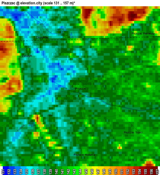
Below is the Elevation map of Piszczac, which displays elevation range with different colors. Scale of the first map is from 131 to 157 m (430 to 515 ft) with average elevation of 140 meters (=459 ft) [note 1]
These maps also provides idea of topography and contour of this city, they are displayed at different zoom levels. More info about maps, scale and edge coordinates you can find below images.
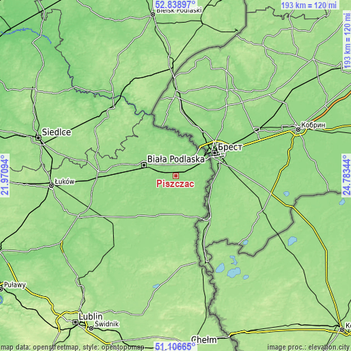
| \ | Map #1 | Topo.Map |
| Scale [m] | 131..157 m | × |
| Scale [ft] | 430..515 ft | × |
| Average | 140 m = 459 ft | × |
| Width | 6.02 km = 3.7 mi | 192.6 km = 119.7 mi |
| Height | 6.02 km = 3.7 mi | 192.6 km = 119.7 mi |
| ↑Max Latitude | 52.008239° | 52.83897° |
| Latitude at center | 51.98118° | 51.98118° |
| ↓Min Latitude | 51.954105° | 51.10665° |
| ← Min Longitude | 23.333245° | 21.97094° |
| Longitude center | 23.37719° | 23.37719° |
| →Max Longitude | 23.421135° | 24.78344° |
Nearby cities:
Cities around Piszczac sort by population:
• Biała Podlaska elevation 142 m
18.7 km,  287°
287°
• Terespol 131 m
19.4 km,  57°
57°
• Janów Podlaski 144 m
26.2 km,  334°
334°
• Sławatycze 154 m
27.1 km,  153°
153°
• Kodeń 143 m
17.3 km,  116°
116°
• Łomazy 147 m
16.2 km,  238°
238°
• Wisznice 152 m
24.3 km,  208°
208°
• Rokitno 150 m
16.6 km,  340°
340°
• Sosnówka 158 m
25.8 km,  185°
185°
• Rossosz 145 m
21.4 km,  230°
230°
• Tuczna 153 m
11.7 km,  163°
163°
• Zalesie 141 m
6.3 km,  351°
351°
Multilingual:
 En español:
Piszczac elevación 141 m.
 En France:
Piszczac élévation 141 m.
 Auf Deutsch:
Piszczac höhe über dem Meeresspiegel ist 141 m.

Sources and notes:
- [note 1] Map square and city borders are not equal. Map elevation data is calculated only from area inside that square.
- [src 1] Elevation data from geonames database provided with same terms of usage.
- [src 2] The elevation map of Piszczac is generated using elevation data from NASA's 3 arcsec (90m) resolution SRTM data.
- [src 3] Base (background) map © OpenStreetMap contributors tiles are generated by Geofabrik and OpenTopoMap.
Copyright & License:
This Piszczac Elevation Map is licensed under CC BY-SA. You may reuse any part from this page, if you give a proper credit by linking to this URL:
 More info on terms of use page.