Puławy elevation
Puławy (Lublin, Powiat puławski), Poland elevation is 137 meters and Puławy elevation in feet is 449 ft above sea level [src 1]. Puławy is a seat of a second-order administrative division (feature code) with elevation that is 54 meters (177 ft) smaller than average city elevation in Poland.
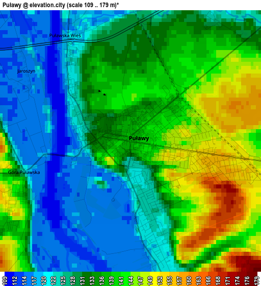
Below is the Elevation map of Puławy, which displays elevation range with different colors. Scale of the first map is from 109 to 179 m (358 to 587 ft) with average elevation of 132.8 meters (=436 ft) [note 1]
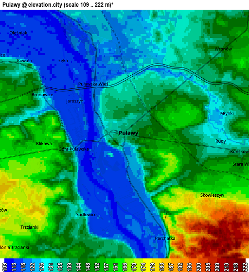
These maps also provides idea of topography and contour of this city, they are displayed at different zoom levels. More info about maps, scale and edge coordinates you can find below images.
| \ | Map #1 | Map #2 | Topo.Map |
| Scale [m] | 109..179 m | 109..222 m | × |
| Scale [ft] | 358..587 ft | 358..728 ft | × |
| Average | 132.8 m = 436 ft | 141.4 m = 464 ft | × |
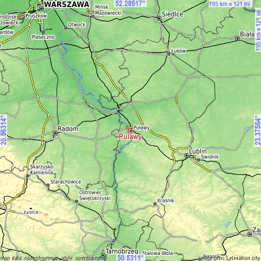
| Width | 6.09 km = 3.8 mi | 12.19 km = 7.6 mi | 195 km = 121.2 mi |
| Height | 6.09 km = 3.8 mi | 12.19 km = 7.6 mi | 195 km = 121.2 mi |
| ↑Max Latitude | 51.443948° | 51.47133° | 52.28517° |
| Latitude at center | 51.41655° | 51.41655° | 51.41655° |
| ↓Min Latitude | 51.389135° | 51.361704° | 50.5311° |
| ← Min Longitude | 21.925445° | 21.881499° | 20.56314° |
| Longitude center | 21.96939° | 21.96939° | 21.96939° |
| →Max Longitude | 22.013335° | 22.057281° | 23.37564° |
Nearby cities:
Cities around Puławy sort by population:
• Dęblin elevation 115 m
17.9 km,  332°
332°
• Kazimierz Dolny 132 m
10.9 km,  185°
185°
• Kurów 159 m
15.4 km,  101°
101°
• Końskowola 139 m
5.8 km, 98°
• Baranów 133 m
19.5 km,  36°
36°
• Markuszów 170 m
20.6 km, 103°
• Żyrzyn 153 m
12.5 km, 42°
• Wąwolnica 159 m
18.3 km,  137°
137°
• Janowiec 125 m
11.7 km,  208°
208°
• Karczmiska 169 m
20.8 km,  177°
177°
• Przyłęk 141 m
19.5 km,  232°
232°
• Wilków 122 m
18.3 km,  200°
200°
Multilingual:
 En español:
Puławy elevación 137 m.
 En France:
Puławy élévation 137 m.
 Auf Deutsch:
Puławy höhe über dem Meeresspiegel ist 137 m.
 На русском:
Пулавы, Ново-Александрия, Новая Александрия высота над уровнем моря 137 м
Sources and notes:
- [note 1] Map square and city borders are not equal. Map elevation data is calculated only from area inside that square.
- [src 1] Elevation data from geonames database provided with same terms of usage.
- [src 2] The elevation map of Puławy is generated using elevation data from NASA's 3 arcsec (90m) resolution SRTM data.
- [src 3] Base (background) map © OpenStreetMap contributors tiles are generated by Geofabrik and OpenTopoMap.
Copyright & License:
This Puławy Elevation Map is licensed under CC BY-SA. You may reuse any part from this page, if you give a proper credit by linking to this URL:
 More info on terms of use page.