Racławice elevation
Racławice (Subcarpathian, Powiat niżański), Poland elevation is 158 meters and Racławice elevation in feet is 518 ft above sea level [src 1]. Racławice is a populated place (feature code) with elevation that is 33 meters (108 ft) smaller than average city elevation in Poland.
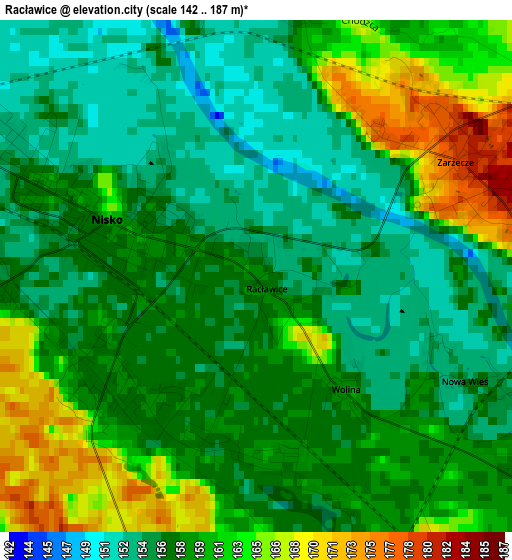
Below is the Elevation map of Racławice, which displays elevation range with different colors. Scale of the first map is from 142 to 187 m (466 to 614 ft) with average elevation of 158.7 meters (=521 ft) [note 1]
These maps also provides idea of topography and contour of this city, they are displayed at different zoom levels. More info about maps, scale and edge coordinates you can find below images.
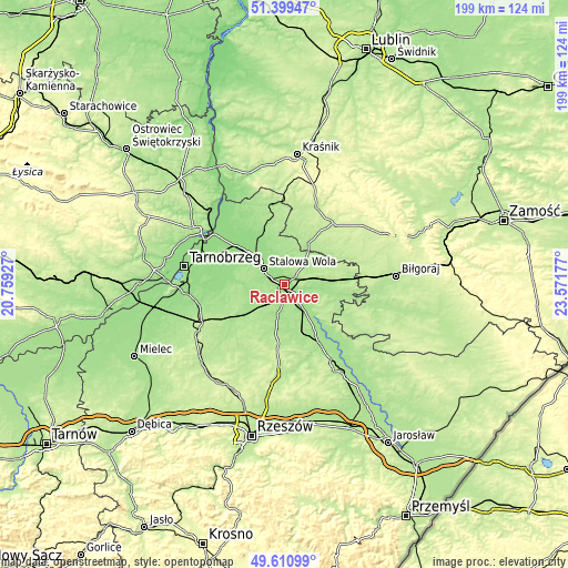
| \ | Map #1 | Topo.Map |
| Scale [m] | 142..187 m | × |
| Scale [ft] | 466..614 ft | × |
| Average | 158.7 m = 521 ft | × |
| Width | 6.21 km = 3.9 mi | 198.9 km = 123.6 mi |
| Height | 6.21 km = 3.9 mi | 198.8 km = 123.5 mi |
| ↑Max Latitude | 50.541636° | 51.39947° |
| Latitude at center | 50.5137° | 50.5137° |
| ↓Min Latitude | 50.485747° | 49.61099° |
| ← Min Longitude | 22.121575° | 20.75927° |
| Longitude center | 22.16552° | 22.16552° |
| →Max Longitude | 22.209465° | 23.57177° |
Nearby cities:
Cities around Racławice sort by population:
• Stalowa Wola elevation 162 m
11 km,  314°
314°
• Nisko 162 m
2 km,  290°
290°
• Rudnik nad Sanem 166 m
9.9 km,  143°
143°
• Jeżowe 175 m
15.7 km,  189°
189°
• Pysznica 154 m
6.8 km,  337°
337°
• Zarzecze 176 m
2.6 km,  53°
53°
• Przędzel 160 m
4.4 km,  119°
119°
• Ulanów 164 m
7.4 km,  110°
110°
• Wólka Tanewska 171 m
6.9 km,  102°
102°
• Jarocin 184 m
12.4 km,  62°
62°
• Bieliny 165 m
12.7 km,  128°
128°
• Kończyce 167 m
9.8 km,  184°
184°
Multilingual:
 En español:
Racławice elevación 158 m.
 En France:
Racławice élévation 158 m.
 Auf Deutsch:
Racławice höhe über dem Meeresspiegel ist 158 m.

Sources and notes:
- [note 1] Map square and city borders are not equal. Map elevation data is calculated only from area inside that square.
- [src 1] Elevation data from geonames database provided with same terms of usage.
- [src 2] The elevation map of Racławice is generated using elevation data from NASA's 3 arcsec (90m) resolution SRTM data.
- [src 3] Base (background) map © OpenStreetMap contributors tiles are generated by Geofabrik and OpenTopoMap.
Copyright & License:
This Racławice Elevation Map is licensed under CC BY-SA. You may reuse any part from this page, if you give a proper credit by linking to this URL:
 More info on terms of use page.