Rytro elevation
Rytro (Lesser Poland, Powiat nowosądecki), Poland elevation is 377 meters and Rytro elevation in feet is 1237 ft above sea level [src 1]. Rytro is a populated place (feature code) with elevation that is 186 meters (610 ft) bigger than average city elevation in Poland.
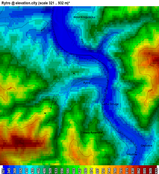
Below is the Elevation map of Rytro, which displays elevation range with different colors. Scale of the first map is from 321 to 932 m (1053 to 3058 ft) with average elevation of 518.5 meters (=1701 ft) [note 1]
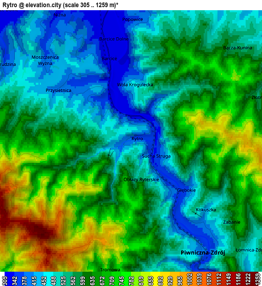
These maps also provides idea of topography and contour of this city, they are displayed at different zoom levels. More info about maps, scale and edge coordinates you can find below images.
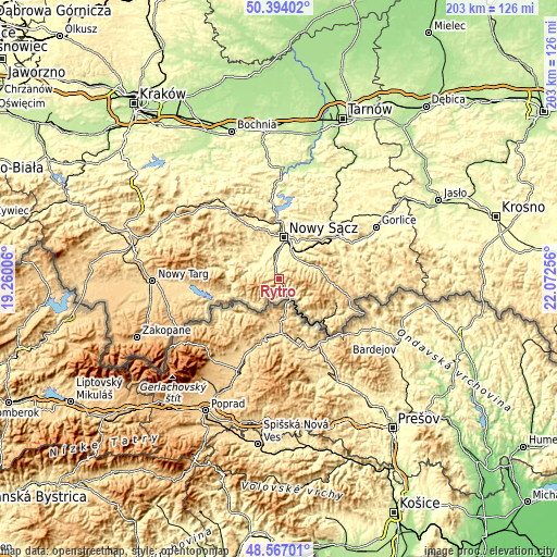
| \ | Map #1 | Map #2 | Topo.Map |
| Scale [m] | 321..932 m | 305..1259 m | × |
| Scale [ft] | 1053..3058 ft | 1001..4131 ft | × |
| Average | 518.5 m = 1701 ft | 601.7 m = 1974 ft | × |
| Width | 6.35 km = 3.9 mi | 12.7 km = 7.9 mi | 203.1 km = 126.2 mi |
| Height | 6.35 km = 3.9 mi | 12.7 km = 7.9 mi | 203.1 km = 126.2 mi |
| ↑Max Latitude | 49.517578° | 49.5461° | 50.39402° |
| Latitude at center | 49.48904° | 49.48904° | 49.48904° |
| ↓Min Latitude | 49.460485° | 49.431914° | 48.56701° |
| ← Min Longitude | 20.622365° | 20.578419° | 19.26006° |
| Longitude center | 20.66631° | 20.66631° | 20.66631° |
| →Max Longitude | 20.710255° | 20.754201° | 22.07256° |
Nearby cities:
Cities around Rytro sort by population:
• Nowy Sącz elevation 293 m
14.9 km,  8°
8°
• Stary Sącz 318 m
8.6 km,  344°
344°
• Szczawnica 464 m
15 km,  241°
241°
• Piwniczna-Zdrój 394 m
6.4 km,  147°
147°
• Krościenko nad Dunajcem 423 m
18.2 km,  252°
252°
• Kamionka Wielka 447 m
14.4 km,  52°
52°
• Łącko 364 m
18.3 km,  294°
294°
• Nawojowa 347 m
10.1 km,  31°
31°
• Chełmiec 281 m
15.7 km,  359°
359°
• Podegrodzie 309 m
11.3 km,  330°
330°
• Olszana 374 m
13.6 km,  309°
309°
• Łabowa 451 m
14.3 km,  72°
72°
Multilingual:
 En español:
Rytro elevación 377 m.
 En France:
Rytro élévation 377 m.


Sources and notes:
- [note 1] Map square and city borders are not equal. Map elevation data is calculated only from area inside that square.
- [src 1] Elevation data from geonames database provided with same terms of usage.
- [src 2] The elevation map of Rytro is generated using elevation data from NASA's 3 arcsec (90m) resolution SRTM data.
- [src 3] Base (background) map © OpenStreetMap contributors tiles are generated by Geofabrik and OpenTopoMap.
Copyright & License:
This Rytro Elevation Map is licensed under CC BY-SA. You may reuse any part from this page, if you give a proper credit by linking to this URL:
 More info on terms of use page.