Słupia elevation
Słupia (Świętokrzyskie, Powiat konecki), Poland elevation is 276 meters and Słupia elevation in feet is 906 ft above sea level [src 1]. Słupia is a seat of a third-order administrative division (feature code) with elevation that is 85 meters (279 ft) bigger than average city elevation in Poland.
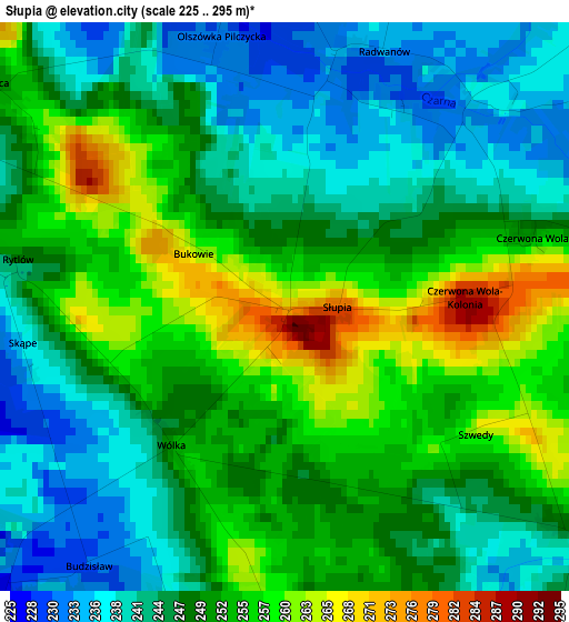
Below is the Elevation map of Słupia, which displays elevation range with different colors. Scale of the first map is from 225 to 295 m (738 to 968 ft) with average elevation of 249 meters (=817 ft) [note 1]
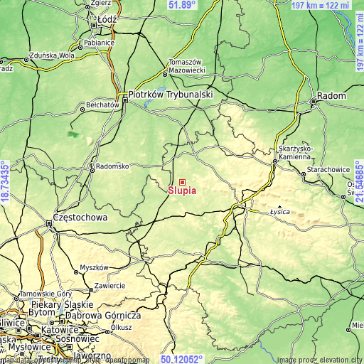
These maps also provides idea of topography and contour of this city, they are displayed at different zoom levels. More info about maps, scale and edge coordinates you can find below images.
| \ | Map #1 | Topo.Map |
| Scale [m] | 225..295 m | × |
| Scale [ft] | 738..968 ft | × |
| Average | 249 m = 817 ft | × |
| Width | 6.15 km = 3.8 mi | 196.7 km = 122.2 mi |
| Height | 6.15 km = 3.8 mi | 196.7 km = 122.2 mi |
| ↑Max Latitude | 51.041339° | 51.89° |
| Latitude at center | 51.0137° | 51.0137° |
| ↓Min Latitude | 50.986044° | 50.12052° |
| ← Min Longitude | 20.096655° | 18.73435° |
| Longitude center | 20.1406° | 20.1406° |
| →Max Longitude | 20.184545° | 21.54685° |
Nearby cities:
Cities around Słupia sort by population:
• Włoszczowa elevation 239 m
21.7 km,  214°
214°
• Małogoszcz 286 m
24 km,  158°
158°
• Przedbórz 199 m
20.4 km,  293°
293°
• Radoszyce 237 m
10.6 km,  50°
50°
• Mniów 275 m
24 km,  90°
90°
• Łopuszno 283 m
10.6 km,  133°
133°
• Krasocin 246 m
14 km,  186°
186°
• Fałków 229 m
13.8 km,  349°
349°
• Strawczyn 256 m
21.2 km,  112°
112°
• Żarnów 239 m
25.9 km,  5°
5°
• Ruda Maleniecka 217 m
15.8 km,  21°
21°
• Smyków 291 m
18.5 km,  79°
79°
Multilingual:
 En español:
Słupia elevación 276 m.
 En France:
Słupia élévation 276 m.


Sources and notes:
- [note 1] Map square and city borders are not equal. Map elevation data is calculated only from area inside that square.
- [src 1] Elevation data from geonames database provided with same terms of usage.
- [src 2] The elevation map of Słupia is generated using elevation data from NASA's 3 arcsec (90m) resolution SRTM data.
- [src 3] Base (background) map © OpenStreetMap contributors tiles are generated by Geofabrik and OpenTopoMap.
Copyright & License:
This Słupia Elevation Map is licensed under CC BY-SA. You may reuse any part from this page, if you give a proper credit by linking to this URL:
 More info on terms of use page.