Strzegowo elevation
Strzegowo (Mazovia, Powiat mławski), Poland elevation is 108 meters and Strzegowo elevation in feet is 354 ft above sea level [src 1]. Strzegowo is a seat of a third-order administrative division (feature code) with elevation that is 83 meters (272 ft) smaller than average city elevation in Poland.
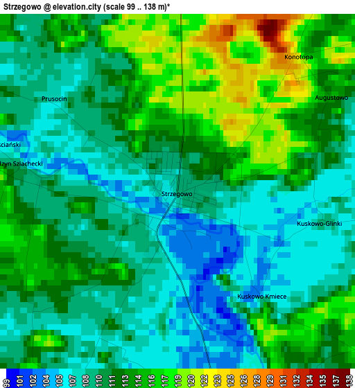
Below is the Elevation map of Strzegowo, which displays elevation range with different colors. Scale of the first map is from 99 to 138 m (325 to 453 ft) with average elevation of 110.9 meters (=364 ft) [note 1]
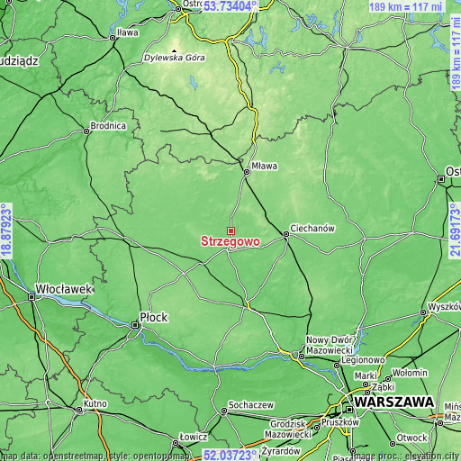
These maps also provides idea of topography and contour of this city, they are displayed at different zoom levels. More info about maps, scale and edge coordinates you can find below images.
| \ | Map #1 | Topo.Map |
| Scale [m] | 99..138 m | × |
| Scale [ft] | 325..453 ft | × |
| Average | 110.9 m = 364 ft | × |
| Width | 5.9 km = 3.7 mi | 188.7 km = 117.3 mi |
| Height | 5.9 km = 3.7 mi | 188.6 km = 117.2 mi |
| ↑Max Latitude | 52.920444° | 53.73404° |
| Latitude at center | 52.89394° | 52.89394° |
| ↓Min Latitude | 52.86742° | 52.03723° |
| ← Min Longitude | 20.241535° | 18.87923° |
| Longitude center | 20.28548° | 20.28548° |
| →Max Longitude | 20.329425° | 21.69173° |
Nearby cities:
Cities around Strzegowo sort by population:
• Ciechanów elevation 119 m
22.5 km,  93°
93°
• Raciąż 103 m
16.8 km,  222°
222°
• Glinojeck 103 m
8.3 km,  176°
176°
• Baboszewo 103 m
23.8 km, 184°
• Szreńsk 115 m
17.2 km,  320°
320°
• Radzanów 110 m
14 km,  292°
292°
• Stupsk 133 m
17.5 km,  35°
35°
• Ojrzeń 105 m
22.4 km,  129°
129°
• Szydłowo 146 m
23.5 km,  28°
28°
• Regimin 127 m
18.7 km,  73°
73°
• Wiśniewo 139 m
19.4 km,  12°
12°
• Siemiątkowo 116 m
17.3 km,  265°
265°
Multilingual:
 En español:
Strzegowo elevación 108 m.
 En France:
Strzegowo élévation 108 m.
 Auf Deutsch:
Strzegowo höhe über dem Meeresspiegel ist 108 m.

Sources and notes:
- [note 1] Map square and city borders are not equal. Map elevation data is calculated only from area inside that square.
- [src 1] Elevation data from geonames database provided with same terms of usage.
- [src 2] The elevation map of Strzegowo is generated using elevation data from NASA's 3 arcsec (90m) resolution SRTM data.
- [src 3] Base (background) map © OpenStreetMap contributors tiles are generated by Geofabrik and OpenTopoMap.
Copyright & License:
This Strzegowo Elevation Map is licensed under CC BY-SA. You may reuse any part from this page, if you give a proper credit by linking to this URL:
 More info on terms of use page.