Supraśl elevation
Supraśl (Podlasie, Powiat białostocki), Poland elevation is 132 meters and Supraśl elevation in feet is 433 ft above sea level [src 1]. Supraśl is a seat of a third-order administrative division (feature code) with elevation that is 59 meters (194 ft) smaller than average city elevation in Poland.
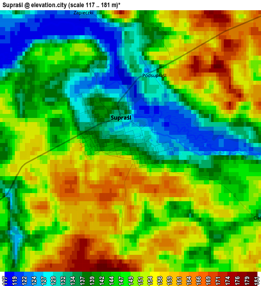
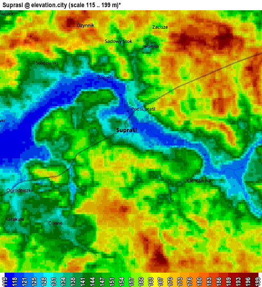
Below is the Elevation map of Supraśl, which displays elevation range with different colors. Scale of the first map is from 117 to 181 m (384 to 594 ft) with average elevation of 146.5 meters (=481 ft) [note 1]
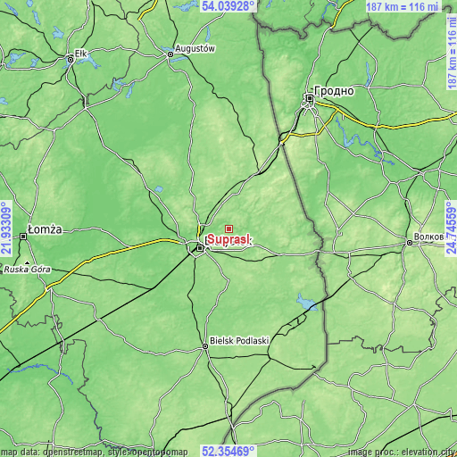
These maps also provides idea of topography and contour of this city, they are displayed at different zoom levels. More info about maps, scale and edge coordinates you can find below images.
| \ | Map #1 | Map #2 | Topo.Map |
| Scale [m] | 117..181 m | 115..199 m | × |
| Scale [ft] | 384..594 ft | 377..653 ft | × |
| Average | 146.5 m = 481 ft | 153.6 m = 504 ft | × |
| Width | 5.85 km = 3.6 mi | 11.71 km = 7.3 mi | 187.3 km = 116.4 mi |
| Height | 5.85 km = 3.6 mi | 11.71 km = 7.3 mi | 187.3 km = 116.4 mi |
| ↑Max Latitude | 53.231573° | 53.25787° | 54.03928° |
| Latitude at center | 53.20526° | 53.20526° | 53.20526° |
| ↓Min Latitude | 53.178931° | 53.152586° | 52.35469° |
| ← Min Longitude | 23.295395° | 23.251449° | 21.93309° |
| Longitude center | 23.33934° | 23.33934° | 23.33934° |
| →Max Longitude | 23.383285° | 23.427231° | 24.74559° |
Nearby cities:
Cities around Supraśl sort by population:
• Białystok elevation 135 m
14.1 km,  235°
235°
• Sokółka 174 m
24.9 km,  25°
25°
• Czarna Białostocka 157 m
11.7 km,  340°
340°
• Wasilków 129 m
8.8 km,  265°
265°
• Grudki 144 m
25.1 km,  119°
119°
• Choroszcz 125 m
24.4 km,  253°
253°
• Michałowo 155 m
26.2 km,  136°
136°
• Krynki 155 m
29.6 km,  77°
77°
• Zabłudów 153 m
21.2 km,  180°
180°
• Dobrzyniewo Duże 124 m
21.9 km, 268°
• Turośń Kościelna 129 m
28.4 km,  221°
221°
• Janów 148 m
30 km,  346°
346°
Multilingual:
 En español:
Supraśl elevación 132 m.
 En France:
Supraśl élévation 132 m.


Sources and notes:
- [note 1] Map square and city borders are not equal. Map elevation data is calculated only from area inside that square.
- [src 1] Elevation data from geonames database provided with same terms of usage.
- [src 2] The elevation map of Supraśl is generated using elevation data from NASA's 3 arcsec (90m) resolution SRTM data.
- [src 3] Base (background) map © OpenStreetMap contributors tiles are generated by Geofabrik and OpenTopoMap.
Copyright & License:
This Supraśl Elevation Map is licensed under CC BY-SA. You may reuse any part from this page, if you give a proper credit by linking to this URL:
 More info on terms of use page.