Węgrzce Wielkie elevation
Węgrzce Wielkie (Lesser Poland, Powiat wielicki), Poland elevation is 204 meters and Węgrzce Wielkie elevation in feet is 669 ft above sea level [src 1]. Węgrzce Wielkie is a populated place (feature code) with elevation that is 13 meters (43 ft) bigger than average city elevation in Poland.
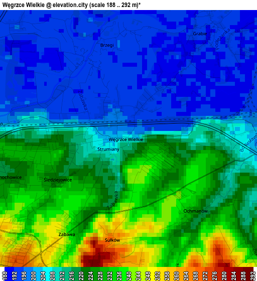
Below is the Elevation map of Węgrzce Wielkie, which displays elevation range with different colors. Scale of the first map is from 188 to 292 m (617 to 958 ft) with average elevation of 213.9 meters (=702 ft) [note 1]
These maps also provides idea of topography and contour of this city, they are displayed at different zoom levels. More info about maps, scale and edge coordinates you can find below images.
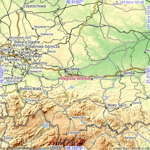
| \ | Map #1 | Topo.Map |
| Scale [m] | 188..292 m | × |
| Scale [ft] | 617..958 ft | × |
| Average | 213.9 m = 702 ft | × |
| Width | 6.28 km = 3.9 mi | 201 km = 124.9 mi |
| Height | 6.28 km = 3.9 mi | 200.9 km = 124.8 mi |
| ↑Max Latitude | 50.04314° | 50.91007° |
| Latitude at center | 50.01491° | 50.01491° |
| ↓Min Latitude | 49.986663° | 49.10276° |
| ← Min Longitude | 20.066875° | 18.70457° |
| Longitude center | 20.11082° | 20.11082° |
| →Max Longitude | 20.154765° | 21.51707° |
Nearby cities:
Cities around Węgrzce Wielkie sort by population:
• Wieliczka elevation 261 m
4.5 km,  227°
227°
• Niepołomice 190 m
8.5 km,  70°
70°
• Rzeszotary 384 m
12.5 km, 232°
• Wola Batorska 187 m
11.9 km, 69°
• Podłęże 203 m
4.1 km,  90°
90°
• Ochojno 387 m
12 km, 234°
• Kokotów 225 m
2.3 km,  263°
263°
• Szarów 229 m
11.6 km,  101°
101°
• Czarnochowice 224 m
3.3 km,  249°
249°
• Pawlikowice 341 m
8 km,  210°
210°
• Trąbki 296 m
6.3 km,  158°
158°
• Tomaszkowice 282 m
4.1 km,  191°
191°
Multilingual:
 En español:
Węgrzce Wielkie elevación 204 m.
 En France:
Węgrzce Wielkie élévation 204 m.
 Auf Deutsch:
Węgrzce Wielkie höhe über dem Meeresspiegel ist 204 m.

Sources and notes:
- [note 1] Map square and city borders are not equal. Map elevation data is calculated only from area inside that square.
- [src 1] Elevation data from geonames database provided with same terms of usage.
- [src 2] The elevation map of Węgrzce Wielkie is generated using elevation data from NASA's 3 arcsec (90m) resolution SRTM data.
- [src 3] Base (background) map © OpenStreetMap contributors tiles are generated by Geofabrik and OpenTopoMap.
Copyright & License:
This Węgrzce Wielkie Elevation Map is licensed under CC BY-SA. You may reuse any part from this page, if you give a proper credit by linking to this URL:
 More info on terms of use page.