Gądów Mały elevation
Gądów Mały (Lower Silesia, Wrocław), Poland elevation is 116 meters and Gądów Mały elevation in feet is 381 ft above sea level [src 1]. Gądów Mały is a section of populated place (feature code) with elevation that is 75 meters (246 ft) smaller than average city elevation in Poland.
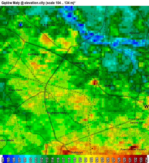
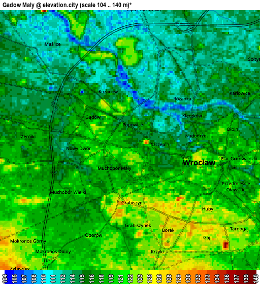
Below is the Elevation map of Gądów Mały, which displays elevation range with different colors. Scale of the first map is from 104 to 134 m (341 to 440 ft) with average elevation of 116.9 meters (=384 ft) [note 1]
These maps also provides idea of topography and contour of this city, they are displayed at different zoom levels. More info about maps, scale and edge coordinates you can find below images.
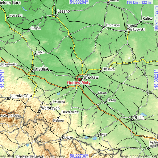
| \ | Map #1 | Map #2 | Topo.Map |
| Scale [m] | 104..134 m | 104..140 m | × |
| Scale [ft] | 341..440 ft | 341..459 ft | × |
| Average | 116.9 m = 384 ft | 117.2 m = 385 ft | × |
| Width | 6.13 km = 3.8 mi | 12.27 km = 7.6 mi | 196.3 km = 122 mi |
| Height | 6.13 km = 3.8 mi | 12.27 km = 7.6 mi | 196.3 km = 122 mi |
| ↑Max Latitude | 51.146107° | 51.173667° | 51.99284° |
| Latitude at center | 51.11853° | 51.11853° | 51.11853° |
| ↓Min Latitude | 51.090937° | 51.063327° | 50.22736° |
| ← Min Longitude | 16.942015° | 16.898069° | 15.57971° |
| Longitude center | 16.98596° | 16.98596° | 16.98596° |
| →Max Longitude | 17.029905° | 17.073851° | 18.39221° |
Nearby cities:
Cities around Gądów Mały sort by population:
• Wrocław elevation 119 m
3.9 km,  121°
121°
• Rejon placu Świętego Macieja 118 m
3.6 km,  86°
86°
• Osiedle Kosmonautów 116 m
2 km,  300°
300°
• Kozanów 112 m
3.1 km,  338°
338°
• Różanka-Polanka 111 m
3.6 km,  40°
40°
• Powstańców Śląskich Zachód-Centrum Południow 121 m
3.3 km,  138°
138°
• Grabiszynek 123 m
3.5 km,  179°
179°
• Rejon ulicy Mieleckiej 123 m
3.2 km,  159°
159°
• Rejon ulicy Klęczkowskiej 115 m
3.6 km,  69°
69°
• Pilczyce 117 m
2.9 km,  316°
316°
• Grabiszyn 125 m
2.8 km,  191°
191°
• Rejon ulicy Saperów 124 m
3.7 km, 164°
Multilingual:
 En español:
Gądów Mały elevación 116 m.
 En France:
Gądów Mały élévation 116 m.
 Auf Deutsch:
Gądów Mały höhe über dem Meeresspiegel ist 116 m.

Sources and notes:
- [note 1] Map square and city borders are not equal. Map elevation data is calculated only from area inside that square.
- [src 1] Elevation data from geonames database provided with same terms of usage.
- [src 2] The elevation map of Gądów Mały is generated using elevation data from NASA's 3 arcsec (90m) resolution SRTM data.
- [src 3] Base (background) map © OpenStreetMap contributors tiles are generated by Geofabrik and OpenTopoMap.
Copyright & License:
This Gądów Mały Elevation Map is licensed under CC BY-SA. You may reuse any part from this page, if you give a proper credit by linking to this URL:
 More info on terms of use page.