Chróścina elevation
Chróścina (Opole Voivodeship, Powiat nyski), Poland elevation is 184 meters and Chróścina elevation in feet is 604 ft above sea level [src 1]. Chróścina is a populated place (feature code) with elevation that is 7 meters (23 ft) smaller than average city elevation in Poland.
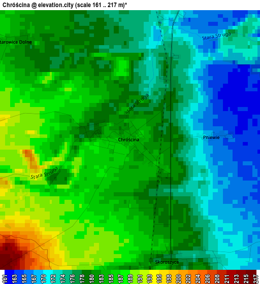
Below is the Elevation map of Chróścina, which displays elevation range with different colors. Scale of the first map is from 161 to 217 m (528 to 712 ft) with average elevation of 179.9 meters (=590 ft) [note 1]
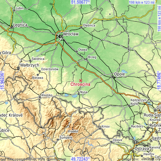
These maps also provides idea of topography and contour of this city, they are displayed at different zoom levels. More info about maps, scale and edge coordinates you can find below images.
| \ | Map #1 | Topo.Map |
| Scale [m] | 161..217 m | × |
| Scale [ft] | 528..712 ft | × |
| Average | 179.9 m = 590 ft | × |
| Width | 6.2 km = 3.9 mi | 198.4 km = 123.3 mi |
| Height | 6.2 km = 3.9 mi | 198.4 km = 123.3 mi |
| ↑Max Latitude | 50.650931° | 51.50677° |
| Latitude at center | 50.62306° | 50.62306° |
| ↓Min Latitude | 50.595172° | 49.72243° |
| ← Min Longitude | 17.324665° | 15.96236° |
| Longitude center | 17.36861° | 17.36861° |
| →Max Longitude | 17.412555° | 18.77486° |
Nearby cities:
Cities around Chróścina sort by population:
• Nysa elevation 191 m
16.8 km,  188°
188°
• Grodków 172 m
8.4 km,  7°
7°
• Niemodlin 161 m
17.8 km,  83°
83°
• Tułowice 174 m
20.3 km,  98°
98°
• Łambinowice 204 m
16.5 km,  124°
124°
• Korfantów 200 m
22.1 km,  132°
132°
• Skoroszyce 179 m
3.1 km,  161°
161°
• Przeworno 188 m
15.9 km,  296°
296°
• Sidzina 169 m
7.9 km, 134°
• Kamiennik 247 m
16.5 km,  249°
249°
• Pakosławice 186 m
8.7 km,  181°
181°
• Olszanka 159 m
20.6 km,  22°
22°
Multilingual:
 En español:
Chróścina elevación 184 m.
 En France:
Chróścina élévation 184 m.
 Auf Deutsch:
Falkenau höhe über dem Meeresspiegel ist 184 m.

Sources and notes:
- [note 1] Map square and city borders are not equal. Map elevation data is calculated only from area inside that square.
- [src 1] Elevation data from geonames database provided with same terms of usage.
- [src 2] The elevation map of Chróścina is generated using elevation data from NASA's 3 arcsec (90m) resolution SRTM data.
- [src 3] Base (background) map © OpenStreetMap contributors tiles are generated by Geofabrik and OpenTopoMap.
Copyright & License:
This Chróścina Elevation Map is licensed under CC BY-SA. You may reuse any part from this page, if you give a proper credit by linking to this URL:
 More info on terms of use page.