Alwernia elevation
Alwernia (Lesser Poland, Powiat chrzanowski), Poland elevation is 276 meters and Alwernia elevation in feet is 906 ft above sea level [src 1]. Alwernia is a seat of a third-order administrative division (feature code) with elevation that is 85 meters (279 ft) bigger than average city elevation in Poland.
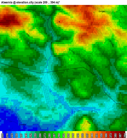
Below is the Elevation map of Alwernia, which displays elevation range with different colors. Scale of the first map is from 209 to 394 m (686 to 1293 ft) with average elevation of 277.5 meters (=910 ft) [note 1]
These maps also provides idea of topography and contour of this city, they are displayed at different zoom levels. More info about maps, scale and edge coordinates you can find below images.
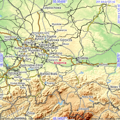
| \ | Map #1 | Topo.Map |
| Scale [m] | 209..394 m | × |
| Scale [ft] | 686..1293 ft | × |
| Average | 277.5 m = 910 ft | × |
| Width | 6.27 km = 3.9 mi | 200.8 km = 124.8 mi |
| Height | 6.27 km = 3.9 mi | 200.7 km = 124.7 mi |
| ↑Max Latitude | 50.088764° | 50.95486° |
| Latitude at center | 50.06056° | 50.06056° |
| ↓Min Latitude | 50.03234° | 49.14927° |
| ← Min Longitude | 19.495585° | 18.13328° |
| Longitude center | 19.53953° | 19.53953° |
| →Max Longitude | 19.583475° | 20.94578° |
Nearby cities:
Cities around Alwernia sort by population:
• Płaza elevation 368 m
6.9 km,  309°
309°
• Spytkowice 227 m
7.4 km,  195°
195°
• Tenczynek 263 m
8.4 km,  38°
38°
• Zalas 351 m
6.2 km,  69°
69°
• Regulice 263 m
2.6 km,  341°
341°
• Kwaczała 251 m
3.4 km,  276°
276°
• Bolęcin 301 m
7.6 km,  326°
326°
• Kamień 259 m
6.3 km,  148°
148°
• Babice 258 m
6.5 km, 278°
• Grojec 361 m
3.5 km,  21°
21°
• Sanka 357 m
7.7 km,  83°
83°
• Brodła 275 m
4 km,  118°
118°
Multilingual:
 En español:
Alwernia elevación 276 m.
 En France:
Alwernia élévation 276 m.
 Auf Deutsch:
Alwernia höhe über dem Meeresspiegel ist 276 m.

Sources and notes:
- [note 1] Map square and city borders are not equal. Map elevation data is calculated only from area inside that square.
- [src 1] Elevation data from geonames database provided with same terms of usage.
- [src 2] The elevation map of Alwernia is generated using elevation data from NASA's 3 arcsec (90m) resolution SRTM data.
- [src 3] Base (background) map © OpenStreetMap contributors tiles are generated by Geofabrik and OpenTopoMap.
Copyright & License:
This Alwernia Elevation Map is licensed under CC BY-SA. You may reuse any part from this page, if you give a proper credit by linking to this URL:
 More info on terms of use page.