Boleszkowice elevation
Boleszkowice (West Pomerania, Powiat myśliborski), Poland elevation is 49 meters and Boleszkowice elevation in feet is 161 ft above sea level [src 1]. Boleszkowice is a seat of a third-order administrative division (feature code) with elevation that is 142 meters (466 ft) smaller than average city elevation in Poland.
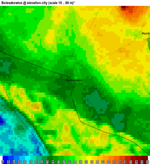
Below is the Elevation map of Boleszkowice, which displays elevation range with different colors. Scale of the first map is from 19 to 88 m (62 to 289 ft) with average elevation of 51.5 meters (=169 ft) [note 1]
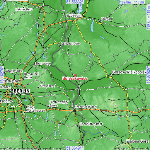
These maps also provides idea of topography and contour of this city, they are displayed at different zoom levels. More info about maps, scale and edge coordinates you can find below images.
| \ | Map #1 | Topo.Map |
| Scale [m] | 19..88 m | × |
| Scale [ft] | 62..289 ft | × |
| Average | 51.5 m = 169 ft | × |
| Width | 5.92 km = 3.7 mi | 189.4 km = 117.7 mi |
| Height | 5.92 km = 3.7 mi | 189.4 km = 117.7 mi |
| ↑Max Latitude | 52.751537° | 53.56832° |
| Latitude at center | 52.72493° | 52.72493° |
| ↓Min Latitude | 52.698307° | 51.86491° |
| ← Min Longitude | 14.525065° | 13.16276° |
| Longitude center | 14.56901° | 14.56901° |
| →Max Longitude | 14.612955° | 15.97526° |
Nearby cities:
Cities around Boleszkowice sort by population:
• Kostrzyn nad Odrą elevation 16 m
16.3 km,  160°
160°
• Dębno 40 m
8.8 km,  79°
79°
• Myślibórz 65 m
29.9 km,  42°
42°
• Chojna 20 m
28.2 km,  340°
340°
• Witnica 22 m
22.9 km,  104°
104°
• Mieszkowice 46 m
8.6 km,  323°
323°
• Słońsk 16 m
24 km,  138°
138°
• Trzcińsko Zdrój 56 m
26.8 km,  5°
5°
• Moryń 58 m
18.9 km, 321°
• Cedynia 4 m
30 km,  304°
304°
• Górzyca 21 m
26.3 km,  167°
167°
• Lubiszyn 55 m
26.2 km, 76°
Multilingual:
 En español:
Boleszkowice elevación 49 m.
 En France:
Boleszkowice élévation 49 m.
 Auf Deutsch:
Boleszkowice höhe über dem Meeresspiegel ist 49 m.

Sources and notes:
- [note 1] Map square and city borders are not equal. Map elevation data is calculated only from area inside that square.
- [src 1] Elevation data from geonames database provided with same terms of usage.
- [src 2] The elevation map of Boleszkowice is generated using elevation data from NASA's 3 arcsec (90m) resolution SRTM data.
- [src 3] Base (background) map © OpenStreetMap contributors tiles are generated by Geofabrik and OpenTopoMap.
Copyright & License:
This Boleszkowice Elevation Map is licensed under CC BY-SA. You may reuse any part from this page, if you give a proper credit by linking to this URL:
 More info on terms of use page.