Brenna elevation
Brenna (Silesia, Powiat cieszyński), Poland elevation is 395 meters and Brenna elevation in feet is 1296 ft above sea level [src 1]. Brenna is a seat of a third-order administrative division (feature code) with elevation that is 204 meters (669 ft) bigger than average city elevation in Poland.
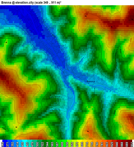
Below is the Elevation map of Brenna, which displays elevation range with different colors. Scale of the first map is from 349 to 911 m (1145 to 2989 ft) with average elevation of 569.1 meters (=1867 ft) [note 1]
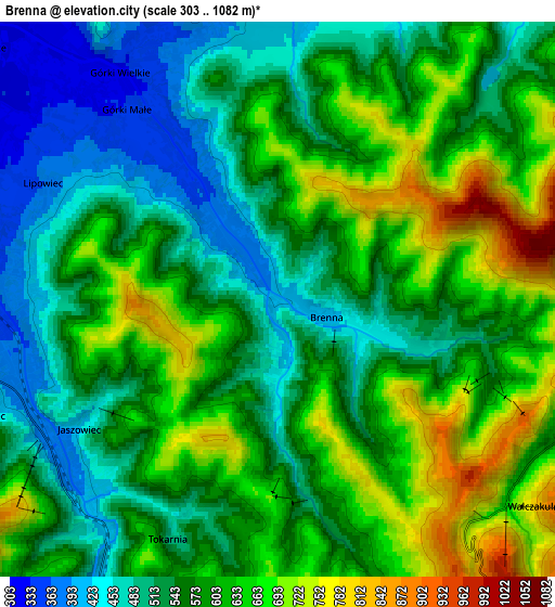
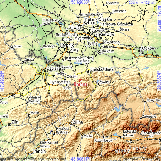
These maps also provides idea of topography and contour of this city, they are displayed at different zoom levels. More info about maps, scale and edge coordinates you can find below images.
| \ | Map #1 | Map #2 | Topo.Map |
| Scale [m] | 349..911 m | 303..1082 m | × |
| Scale [ft] | 1145..2989 ft | 994..3550 ft | × |
| Average | 569.1 m = 1867 ft | 579.9 m = 1903 ft | × |
| Width | 6.32 km = 3.9 mi | 12.63 km = 7.8 mi | 202.2 km = 125.6 mi |
| Height | 6.32 km = 3.9 mi | 12.63 km = 7.8 mi | 202.1 km = 125.6 mi |
| ↑Max Latitude | 49.75416° | 49.782543° | 50.62633° |
| Latitude at center | 49.72576° | 49.72576° | 49.72576° |
| ↓Min Latitude | 49.697343° | 49.66891° | 48.80817° |
| ← Min Longitude | 18.858545° | 18.814599° | 17.49624° |
| Longitude center | 18.90249° | 18.90249° | 18.90249° |
| →Max Longitude | 18.946435° | 18.990381° | 20.30874° |
Nearby cities:
Cities around Brenna sort by population:
• Ustroń elevation 355 m
7.2 km,  266°
266°
• Skoczów 293 m
11.7 km,  315°
315°
• Wisła 428 m
8.3 km,  202°
202°
• Jaworze 381 m
8.2 km,  23°
23°
• Szczyrk 501 m
9.3 km,  95°
95°
• Jasienica 322 m
9.8 km,  8°
8°
• Buczkowice 446 m
12 km,  88°
88°
• Goleszów 368 m
12 km,  275°
275°
• Bystra 439 m
11.9 km,  71°
71°
• Górki Wielkie 314 m
7.9 km, 319°
• Pogórze 339 m
9.2 km,  332°
332°
• Cisownica 380 m
10.1 km, 268°
Multilingual:
 En español:
Brenna elevación 395 m.
 En France:
Brenna élévation 395 m.


Sources and notes:
- [note 1] Map square and city borders are not equal. Map elevation data is calculated only from area inside that square.
- [src 1] Elevation data from geonames database provided with same terms of usage.
- [src 2] The elevation map of Brenna is generated using elevation data from NASA's 3 arcsec (90m) resolution SRTM data.
- [src 3] Base (background) map © OpenStreetMap contributors tiles are generated by Geofabrik and OpenTopoMap.
Copyright & License:
This Brenna Elevation Map is licensed under CC BY-SA. You may reuse any part from this page, if you give a proper credit by linking to this URL:
 More info on terms of use page.