Czarny Dunajec elevation
Czarny Dunajec (Lesser Poland, Powiat nowotarski), Poland elevation is 678 meters and Czarny Dunajec elevation in feet is 2224 ft above sea level [src 1]. Czarny Dunajec is a seat of a third-order administrative division (feature code) with elevation that is 487 meters (1598 ft) bigger than average city elevation in Poland.
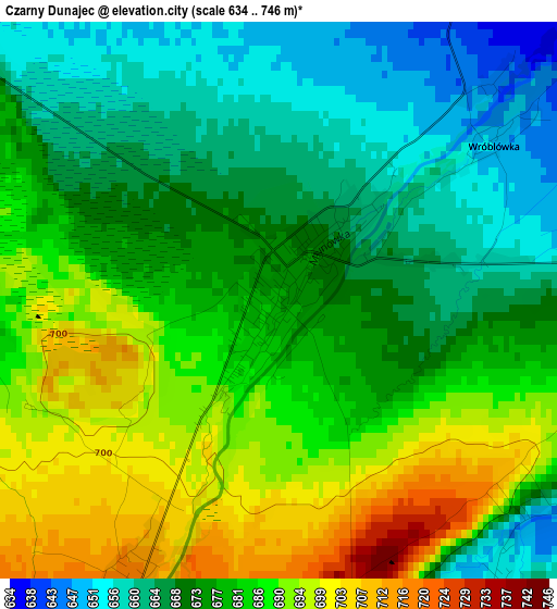
Below is the Elevation map of Czarny Dunajec, which displays elevation range with different colors. Scale of the first map is from 634 to 746 m (2080 to 2448 ft) with average elevation of 678.2 meters (=2225 ft) [note 1]
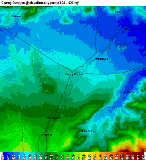
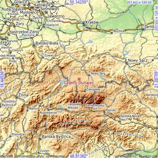
These maps also provides idea of topography and contour of this city, they are displayed at different zoom levels. More info about maps, scale and edge coordinates you can find below images.
| \ | Map #1 | Map #2 | Topo.Map |
| Scale [m] | 634..746 m | 608..923 m | × |
| Scale [ft] | 2080..2448 ft | 1995..3028 ft | × |
| Average | 678.2 m = 2225 ft | 680 m = 2231 ft | × |
| Width | 6.35 km = 3.9 mi | 12.71 km = 7.9 mi | 203.4 km = 126.4 mi |
| Height | 6.35 km = 3.9 mi | 12.71 km = 7.9 mi | 203.3 km = 126.3 mi |
| ↑Max Latitude | 49.465199° | 49.493751° | 50.34259° |
| Latitude at center | 49.43663° | 49.43663° | 49.43663° |
| ↓Min Latitude | 49.408045° | 49.379442° | 48.51362° |
| ← Min Longitude | 19.807665° | 19.763719° | 18.44536° |
| Longitude center | 19.85161° | 19.85161° | 19.85161° |
| →Max Longitude | 19.895555° | 19.939501° | 21.25786° |
Nearby cities:
Cities around Czarny Dunajec sort by population:
• Nowy Targ elevation 595 m
13.8 km,  70°
70°
• Jabłonka 617 m
12.4 km,  292°
292°
• Biały Dunajec 696 m
13.4 km,  121°
121°
• Raba Wyżna 522 m
14.6 km,  7°
7°
• Ludźmierz 599 m
10 km, 70°
• Podwilk 673 m
14.8 km,  326°
326°
• Piekielnik 646 m
7.5 km,  306°
306°
• Szaflary 638 m
12.7 km,  95°
95°
• Sieniawa 625 m
12.8 km,  26°
26°
• Klikuszowa 674 m
13.3 km,  46°
46°
• Lasek 654 m
12.3 km, 49°
• Chyżne 651 m
13.2 km,  265°
265°
Multilingual:
 En español:
Czarny Dunajec elevación 678 m.
 En France:
Czarny Dunajec élévation 678 m.
 Auf Deutsch:
Czarny Dunajec höhe über dem Meeresspiegel ist 678 m.

Sources and notes:
- [note 1] Map square and city borders are not equal. Map elevation data is calculated only from area inside that square.
- [src 1] Elevation data from geonames database provided with same terms of usage.
- [src 2] The elevation map of Czarny Dunajec is generated using elevation data from NASA's 3 arcsec (90m) resolution SRTM data.
- [src 3] Base (background) map © OpenStreetMap contributors tiles are generated by Geofabrik and OpenTopoMap.
Copyright & License:
This Czarny Dunajec Elevation Map is licensed under CC BY-SA. You may reuse any part from this page, if you give a proper credit by linking to this URL:
 More info on terms of use page.