Czerwieńsk elevation
Czerwieńsk (Lubusz, Powiat zielonogórski), Poland elevation is 55 meters and Czerwieńsk elevation in feet is 180 ft above sea level [src 1]. Czerwieńsk is a seat of a third-order administrative division (feature code) with elevation that is 136 meters (446 ft) smaller than average city elevation in Poland.
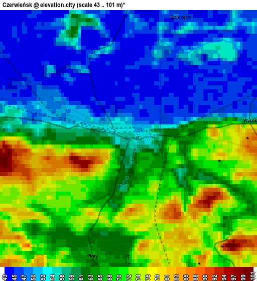
Below is the Elevation map of Czerwieńsk, which displays elevation range with different colors. Scale of the first map is from 43 to 101 m (141 to 331 ft) with average elevation of 61.1 meters (=200 ft) [note 1]
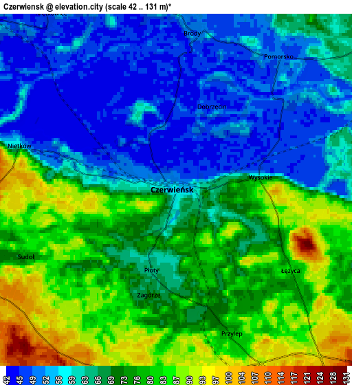
These maps also provides idea of topography and contour of this city, they are displayed at different zoom levels. More info about maps, scale and edge coordinates you can find below images.
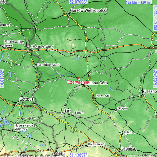
| \ | Map #1 | Map #2 | Topo.Map |
| Scale [m] | 43..101 m | 42..131 m | × |
| Scale [ft] | 141..331 ft | 138..430 ft | × |
| Average | 61.1 m = 200 ft | 67.7 m = 222 ft | × |
| Width | 6.01 km = 3.7 mi | 12.03 km = 7.5 mi | 192.5 km = 119.6 mi |
| Height | 6.01 km = 3.7 mi | 12.03 km = 7.5 mi | 192.5 km = 119.6 mi |
| ↑Max Latitude | 52.039929° | 52.066953° | 52.87006° |
| Latitude at center | 52.01289° | 52.01289° | 52.01289° |
| ↓Min Latitude | 51.985834° | 51.958762° | 51.13897° |
| ← Min Longitude | 15.379225° | 15.335279° | 14.01692° |
| Longitude center | 15.42317° | 15.42317° | 15.42317° |
| →Max Longitude | 15.467115° | 15.511061° | 16.82942° |
Nearby cities:
Cities around Czerwieńsk sort by population:
• Zielona Góra elevation 143 m
10.3 km,  146°
146°
• Sulechów 85 m
15.9 km,  60°
60°
• Krosno Odrzańskie 82 m
22.7 km,  281°
281°
• Międzylesie 80 m
14.9 km,  349°
349°
• Ochla 88 m
15.2 km,  167°
167°
• Świdnica 101 m
14 km,  189°
189°
• Bytnica 70 m
23.1 km,  311°
311°
• Zabór 63 m
21.2 km,  108°
108°
• Trzebiechów 54 m
21.4 km,  87°
87°
• Bobrowice 62 m
23.9 km,  252°
252°
• Skąpe 80 m
15.8 km,  8°
8°
• Dąbie 79 m
18.5 km,  269°
269°
Multilingual:
 En español:
Czerwieńsk elevación 55 m.
 En France:
Czerwieńsk élévation 55 m.
 Auf Deutsch:
Czerwieńsk höhe über dem Meeresspiegel ist 55 m.

Sources and notes:
- [note 1] Map square and city borders are not equal. Map elevation data is calculated only from area inside that square.
- [src 1] Elevation data from geonames database provided with same terms of usage.
- [src 2] The elevation map of Czerwieńsk is generated using elevation data from NASA's 3 arcsec (90m) resolution SRTM data.
- [src 3] Base (background) map © OpenStreetMap contributors tiles are generated by Geofabrik and OpenTopoMap.
Copyright & License:
This Czerwieńsk Elevation Map is licensed under CC BY-SA. You may reuse any part from this page, if you give a proper credit by linking to this URL:
 More info on terms of use page.