Komprachcice elevation
Komprachcice (Opole Voivodeship, Powiat opolski), Poland elevation is 169 meters and Komprachcice elevation in feet is 554 ft above sea level [src 1]. Komprachcice is a populated place (feature code) with elevation that is 22 meters (72 ft) smaller than average city elevation in Poland.
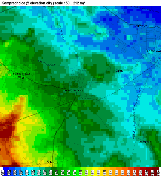
Below is the Elevation map of Komprachcice, which displays elevation range with different colors. Scale of the first map is from 150 to 212 m (492 to 696 ft) with average elevation of 168.1 meters (=552 ft) [note 1]
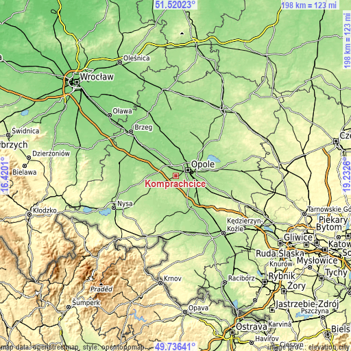
These maps also provides idea of topography and contour of this city, they are displayed at different zoom levels. More info about maps, scale and edge coordinates you can find below images.
| \ | Map #1 | Topo.Map |
| Scale [m] | 150..212 m | × |
| Scale [ft] | 492..696 ft | × |
| Average | 168.1 m = 552 ft | × |
| Width | 6.2 km = 3.9 mi | 198.3 km = 123.2 mi |
| Height | 6.2 km = 3.9 mi | 198.3 km = 123.2 mi |
| ↑Max Latitude | 50.664643° | 51.52023° |
| Latitude at center | 50.63678° | 50.63678° |
| ↓Min Latitude | 50.6089° | 49.73641° |
| ← Min Longitude | 17.782405° | 16.4201° |
| Longitude center | 17.82635° | 17.82635° |
| →Max Longitude | 17.870295° | 19.2326° |
Nearby cities:
Cities around Komprachcice sort by population:
• Opole elevation 167 m
8 km,  60°
60°
• Niemodlin 161 m
14.6 km,  272°
272°
• Dobrzeń Wielki 148 m
14.7 km,  5°
5°
• Tułowice 174 m
13 km,  249°
249°
• Czarnowąsy 150 m
11.4 km,  26°
26°
• Chróścice 146 m
16 km,  356°
356°
• Prószków 184 m
7.4 km,  154°
154°
• Chrościna 164 m
3.3 km,  349°
349°
• Chmielowice 159 m
3.2 km, 63°
• Chrząstowice 164 m
17.7 km,  79°
79°
• Skorogoszcz 145 m
17 km,  323°
323°
• Dąbrowa 168 m
7.5 km,  313°
313°
Multilingual:
 En español:
Komprachcice elevación 169 m.
 En France:
Komprachcice élévation 169 m.
 Auf Deutsch:
Komprachcice höhe über dem Meeresspiegel ist 169 m.

Sources and notes:
- [note 1] Map square and city borders are not equal. Map elevation data is calculated only from area inside that square.
- [src 1] Elevation data from geonames database provided with same terms of usage.
- [src 2] The elevation map of Komprachcice is generated using elevation data from NASA's 3 arcsec (90m) resolution SRTM data.
- [src 3] Base (background) map © OpenStreetMap contributors tiles are generated by Geofabrik and OpenTopoMap.
Copyright & License:
This Komprachcice Elevation Map is licensed under CC BY-SA. You may reuse any part from this page, if you give a proper credit by linking to this URL:
 More info on terms of use page.