Konin elevation
Konin (Greater Poland), Poland elevation is 83 meters and Konin elevation in feet is 272 ft above sea level [src 1]. Konin is a populated place (feature code) with elevation that is 108 meters (354 ft) smaller than average city elevation in Poland.
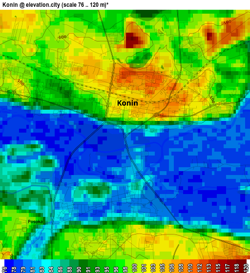
Below is the Elevation map of Konin, which displays elevation range with different colors. Scale of the first map is from 76 to 120 m (249 to 394 ft) with average elevation of 91.5 meters (=300 ft) [note 1]
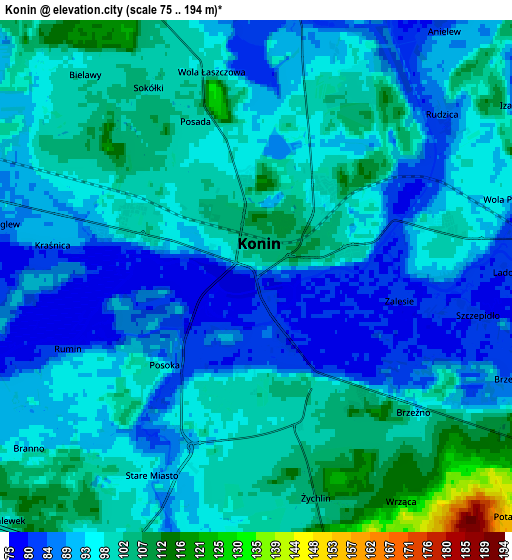
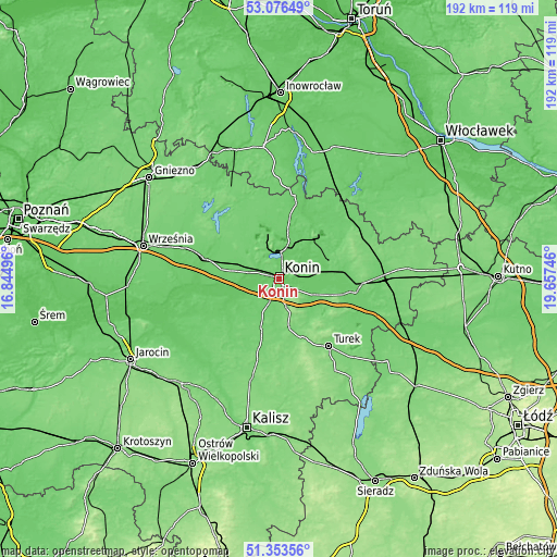
These maps also provides idea of topography and contour of this city, they are displayed at different zoom levels. More info about maps, scale and edge coordinates you can find below images.
| \ | Map #1 | Map #2 | Topo.Map |
| Scale [m] | 76..120 m | 75..194 m | × |
| Scale [ft] | 249..394 ft | 246..636 ft | × |
| Average | 91.5 m = 300 ft | 95.6 m = 314 ft | × |
| Width | 5.99 km = 3.7 mi | 11.97 km = 7.4 mi | 191.6 km = 119.1 mi |
| Height | 5.99 km = 3.7 mi | 11.97 km = 7.4 mi | 191.6 km = 119.1 mi |
| ↑Max Latitude | 52.250292° | 52.277188° | 53.07649° |
| Latitude at center | 52.22338° | 52.22338° | 52.22338° |
| ↓Min Latitude | 52.196452° | 52.169507° | 51.35356° |
| ← Min Longitude | 18.207265° | 18.163319° | 16.84496° |
| Longitude center | 18.25121° | 18.25121° | 18.25121° |
| →Max Longitude | 18.295155° | 18.339101° | 19.65746° |
Nearby cities:
Cities around Konin sort by population:
• Golina elevation 94 m
11 km,  281°
281°
• Kazimierz Biskupi 94 m
11.3 km,  329°
329°
• Kleczew 96 m
17.1 km,  342°
342°
• Tuliszków 130 m
16.6 km,  169°
169°
• Ślesin 91 m
16.8 km,  12°
12°
• Rychwał 105 m
17.9 km,  199°
199°
• Kramsk 85 m
12.6 km,  68°
68°
• Władysławów 115 m
20.4 km,  131°
131°
• Stare Miasto 90 m
5.4 km,  206°
206°
• Licheń Stary 85 m
12.2 km,  35°
35°
• Rzgów Pierwszy 89 m
15.9 km,  239°
239°
• Krzymów 85 m
12.8 km,  107°
107°
Multilingual:
 En español:
Konin elevación 83 m.
 En France:
Konin élévation 83 m.


Sources and notes:
- [note 1] Map square and city borders are not equal. Map elevation data is calculated only from area inside that square.
- [src 1] Elevation data from geonames database provided with same terms of usage.
- [src 2] The elevation map of Konin is generated using elevation data from NASA's 3 arcsec (90m) resolution SRTM data.
- [src 3] Base (background) map © OpenStreetMap contributors tiles are generated by Geofabrik and OpenTopoMap.
Copyright & License:
This Konin Elevation Map is licensed under CC BY-SA. You may reuse any part from this page, if you give a proper credit by linking to this URL:
 More info on terms of use page.