Kutno elevation
Kutno (Łódź Voivodeship, Powiat kutnowski), Poland elevation is 112 meters and Kutno elevation in feet is 367 ft above sea level [src 1]. Kutno is a seat of a second-order administrative division (feature code) with elevation that is 79 meters (259 ft) smaller than average city elevation in Poland.
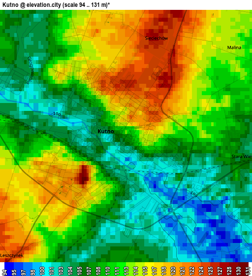
Below is the Elevation map of Kutno, which displays elevation range with different colors. Scale of the first map is from 94 to 131 m (308 to 430 ft) with average elevation of 110.4 meters (=362 ft) [note 1]
These maps also provides idea of topography and contour of this city, they are displayed at different zoom levels. More info about maps, scale and edge coordinates you can find below images.
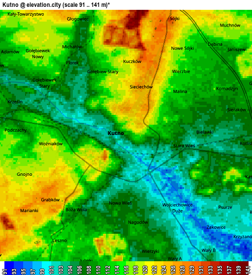
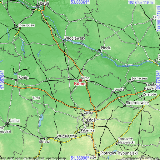
| \ | Map #1 | Map #2 | Topo.Map |
| Scale [m] | 94..131 m | 91..141 m | × |
| Scale [ft] | 308..430 ft | 299..463 ft | × |
| Average | 110.4 m = 362 ft | 112.2 m = 368 ft | × |
| Width | 5.99 km = 3.7 mi | 11.97 km = 7.4 mi | 191.5 km = 119 mi |
| Height | 5.99 km = 3.7 mi | 11.97 km = 7.4 mi | 191.5 km = 119 mi |
| ↑Max Latitude | 52.257548° | 52.284439° | 53.08361° |
| Latitude at center | 52.23064° | 52.23064° | 52.23064° |
| ↓Min Latitude | 52.203716° | 52.176776° | 51.36096° |
| ← Min Longitude | 19.320145° | 19.276199° | 17.95784° |
| Longitude center | 19.36409° | 19.36409° | 19.36409° |
| →Max Longitude | 19.408035° | 19.451981° | 20.77034° |
Nearby cities:
Cities around Kutno sort by population:
• Żychlin elevation 100 m
17.9 km,  85°
85°
• Krośniewice 124 m
13.5 km,  282°
282°
• Ostrowy 123 m
15.8 km,  301°
301°
• Witonia 102 m
10.3 km,  204°
204°
• Strzelce 132 m
9.8 km,  17°
17°
• Bedlno 106 m
14.6 km,  99°
99°
• Łanięta 128 m
15.7 km,  338°
338°
• Daszyna 132 m
15 km,  235°
235°
• Nowe Ostrowy 117 m
14.2 km, 304°
• Góra Świętej Małgorzaty 114 m
19.5 km,  188°
188°
• Krzyżanów 97 m
8.1 km,  129°
129°
• Oporów 100 m
14.1 km,  74°
74°
Multilingual:
 En español:
Kutno elevación 112 m.
 En France:
Kutno élévation 112 m.


Sources and notes:
- [note 1] Map square and city borders are not equal. Map elevation data is calculated only from area inside that square.
- [src 1] Elevation data from geonames database provided with same terms of usage.
- [src 2] The elevation map of Kutno is generated using elevation data from NASA's 3 arcsec (90m) resolution SRTM data.
- [src 3] Base (background) map © OpenStreetMap contributors tiles are generated by Geofabrik and OpenTopoMap.
Copyright & License:
This Kutno Elevation Map is licensed under CC BY-SA. You may reuse any part from this page, if you give a proper credit by linking to this URL:
 More info on terms of use page.