Łagiewniki elevation
Łagiewniki (Lower Silesia, Powiat dzierżoniowski), Poland elevation is 177 meters and Łagiewniki elevation in feet is 581 ft above sea level [src 1]. Łagiewniki is a populated place (feature code) with elevation that is 14 meters (46 ft) smaller than average city elevation in Poland.
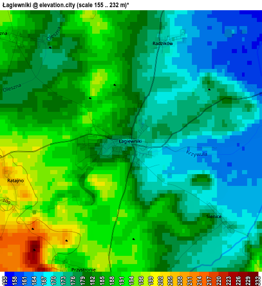
Below is the Elevation map of Łagiewniki, which displays elevation range with different colors. Scale of the first map is from 155 to 232 m (509 to 761 ft) with average elevation of 180.7 meters (=593 ft) [note 1]
These maps also provides idea of topography and contour of this city, they are displayed at different zoom levels. More info about maps, scale and edge coordinates you can find below images.
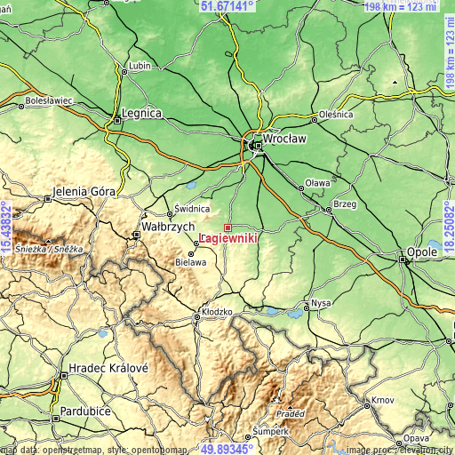
| \ | Map #1 | Topo.Map |
| Scale [m] | 155..232 m | × |
| Scale [ft] | 509..761 ft | × |
| Average | 180.7 m = 593 ft | × |
| Width | 6.18 km = 3.8 mi | 197.7 km = 122.8 mi |
| Height | 6.18 km = 3.8 mi | 197.7 km = 122.8 mi |
| ↑Max Latitude | 50.818652° | 51.67141° |
| Latitude at center | 50.79088° | 50.79088° |
| ↓Min Latitude | 50.763092° | 49.89345° |
| ← Min Longitude | 16.800625° | 15.43832° |
| Longitude center | 16.84457° | 16.84457° |
| →Max Longitude | 16.888515° | 18.25082° |
Nearby cities:
Cities around Łagiewniki sort by population:
• Dzierżoniów elevation 278 m
15.3 km,  242°
242°
• Bielawa 297 m
19.2 km,  234°
234°
• Strzelin 164 m
15.5 km,  93°
93°
• Pieszyce 299 m
20.4 km, 244°
• Sobótka 183 m
14 km,  329°
329°
• Piława Górna 304 m
13.9 km,  210°
210°
• Henryków 208 m
19.2 km,  142°
142°
• Niemcza 205 m
7.9 km,  184°
184°
• Kobierzyce 137 m
21 km,  17°
17°
• Ciepłowody 272 m
13.7 km,  160°
160°
• Uciechów 260 m
12.1 km,  250°
250°
• Jordanów Śląski 154 m
8.3 km,  11°
11°
Multilingual:
 En español:
Łagiewniki elevación 177 m.
 En France:
Łagiewniki élévation 177 m.
 Auf Deutsch:
Łagiewniki höhe über dem Meeresspiegel ist 177 m.

Sources and notes:
- [note 1] Map square and city borders are not equal. Map elevation data is calculated only from area inside that square.
- [src 1] Elevation data from geonames database provided with same terms of usage.
- [src 2] The elevation map of Łagiewniki is generated using elevation data from NASA's 3 arcsec (90m) resolution SRTM data.
- [src 3] Base (background) map © OpenStreetMap contributors tiles are generated by Geofabrik and OpenTopoMap.
Copyright & License:
This Łagiewniki Elevation Map is licensed under CC BY-SA. You may reuse any part from this page, if you give a proper credit by linking to this URL:
 More info on terms of use page.