Łąka Prudnicka elevation
Łąka Prudnicka (Opole Voivodeship, Powiat prudnicki), Poland elevation is 280 meters and Łąka Prudnicka elevation in feet is 919 ft above sea level [src 1]. Łąka Prudnicka is a populated place (feature code) with elevation that is 89 meters (292 ft) bigger than average city elevation in Poland.
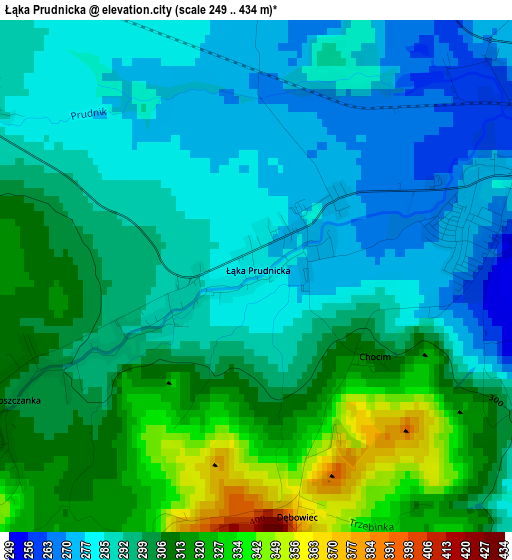
Below is the Elevation map of Łąka Prudnicka, which displays elevation range with different colors. Scale of the first map is from 249 to 434 m (817 to 1424 ft) with average elevation of 297.3 meters (=975 ft) [note 1]
These maps also provides idea of topography and contour of this city, they are displayed at different zoom levels. More info about maps, scale and edge coordinates you can find below images.
| \ | Map #1 | Topo.Map |
| Scale [m] | 249..434 m | × |
| Scale [ft] | 817..1424 ft | × |
| Average | 297.3 m = 975 ft | × |
| Width | 6.24 km = 3.9 mi | 199.7 km = 124.1 mi |
| Height | 6.24 km = 3.9 mi | 199.7 km = 124.1 mi |
| ↑Max Latitude | 50.338666° | 51.20021° |
| Latitude at center | 50.31061° | 50.31061° |
| ↓Min Latitude | 50.282537° | 49.40405° |
| ← Min Longitude | 17.484145° | 16.12184° |
| Longitude center | 17.52809° | 17.52809° |
| →Max Longitude | 17.572035° | 18.93434° |
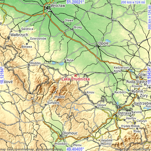
Nearby cities:
Cities around Łąka Prudnicka sort by population:
• Nysa elevation 191 m
22.8 km,  322°
322°
• Prudnik 270 m
3.5 km,  70°
70°
• Głuchołazy 288 m
10.3 km,  272°
272°
• Głubczyce 273 m
24.6 km,  119°
119°
• Głogówek 208 m
24.3 km,  78°
78°
• Łambinowice 204 m
25.5 km,  5°
5°
• Biała 234 m
12.6 km,  48°
48°
• Korfantów 200 m
20.5 km, 14°
• Racławice Śląskie 205 m
17.6 km,  89°
89°
• Moszczanka 301 m
2.9 km,  246°
246°
• Lubrza 248 m
7.5 km, 67°
• Pakosławice 186 m
28.5 km,  336°
336°
Multilingual:
 En español:
Łąka Prudnicka elevación 280 m.
 En France:
Łąka Prudnicka élévation 280 m.
 Auf Deutsch:
Łąka Prudnicka höhe über dem Meeresspiegel ist 280 m.

Sources and notes:
- [note 1] Map square and city borders are not equal. Map elevation data is calculated only from area inside that square.
- [src 1] Elevation data from geonames database provided with same terms of usage.
- [src 2] The elevation map of Łąka Prudnicka is generated using elevation data from NASA's 3 arcsec (90m) resolution SRTM data.
- [src 3] Base (background) map © OpenStreetMap contributors tiles are generated by Geofabrik and OpenTopoMap.
Copyright & License:
This Łąka Prudnicka Elevation Map is licensed under CC BY-SA. You may reuse any part from this page, if you give a proper credit by linking to this URL:
 More info on terms of use page.