Maszewo Duże elevation
Maszewo Duże (Mazovia, Powiat płocki), Poland elevation is 109 meters and Maszewo Duże elevation in feet is 358 ft above sea level [src 1]. Maszewo Duże is a populated place (feature code) with elevation that is 82 meters (269 ft) smaller than average city elevation in Poland.
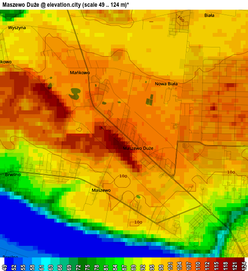
Below is the Elevation map of Maszewo Duże, which displays elevation range with different colors. Scale of the first map is from 49 to 124 m (161 to 407 ft) with average elevation of 94.8 meters (=311 ft) [note 1]
These maps also provides idea of topography and contour of this city, they are displayed at different zoom levels. More info about maps, scale and edge coordinates you can find below images.
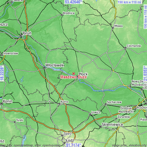
| \ | Map #1 | Topo.Map |
| Scale [m] | 49..124 m | × |
| Scale [ft] | 161..407 ft | × |
| Average | 94.8 m = 311 ft | × |
| Width | 5.94 km = 3.7 mi | 190 km = 118.1 mi |
| Height | 5.94 km = 3.7 mi | 190 km = 118.1 mi |
| ↑Max Latitude | 52.606955° | 53.42646° |
| Latitude at center | 52.58026° | 52.58026° |
| ↓Min Latitude | 52.553549° | 51.7174° |
| ← Min Longitude | 19.585105° | 18.2228° |
| Longitude center | 19.62905° | 19.62905° |
| →Max Longitude | 19.672995° | 21.0353° |
Nearby cities:
Cities around Maszewo Duże sort by population:
• Płock elevation 103 m
6.4 km,  125°
125°
• Gostynin 89 m
20.2 km,  213°
213°
• Gąbin 101 m
21.4 km,  160°
160°
• Bielsk 134 m
15.6 km,  49°
49°
• Gozdowo 130 m
16.5 km,  13°
13°
• Łąck 84 m
12.7 km,  185°
185°
• Radzanowo 140 m
17.7 km,  92°
92°
• Brudzeń Duży 89 m
13 km,  319°
319°
• Nowy Duninów 57 m
10.1 km,  271°
271°
• Słupno 90 m
16.3 km,  120°
120°
• Biała 100 m
3.1 km,  26°
26°
• Mochowo 106 m
21.2 km,  346°
346°
Multilingual:
 En español:
Maszewo Duże elevación 109 m.
 En France:
Maszewo Duże élévation 109 m.
 Auf Deutsch:
Maszewo Duże höhe über dem Meeresspiegel ist 109 m.

Sources and notes:
- [note 1] Map square and city borders are not equal. Map elevation data is calculated only from area inside that square.
- [src 1] Elevation data from geonames database provided with same terms of usage.
- [src 2] The elevation map of Maszewo Duże is generated using elevation data from NASA's 3 arcsec (90m) resolution SRTM data.
- [src 3] Base (background) map © OpenStreetMap contributors tiles are generated by Geofabrik and OpenTopoMap.
Copyright & License:
This Maszewo Duże Elevation Map is licensed under CC BY-SA. You may reuse any part from this page, if you give a proper credit by linking to this URL:
 More info on terms of use page.