Mierzęcice elevation
Mierzęcice (Silesia, Powiat będziński), Poland elevation is 316 meters and Mierzęcice elevation in feet is 1037 ft above sea level [src 1]. Mierzęcice is a seat of a third-order administrative division (feature code) with elevation that is 125 meters (410 ft) bigger than average city elevation in Poland.
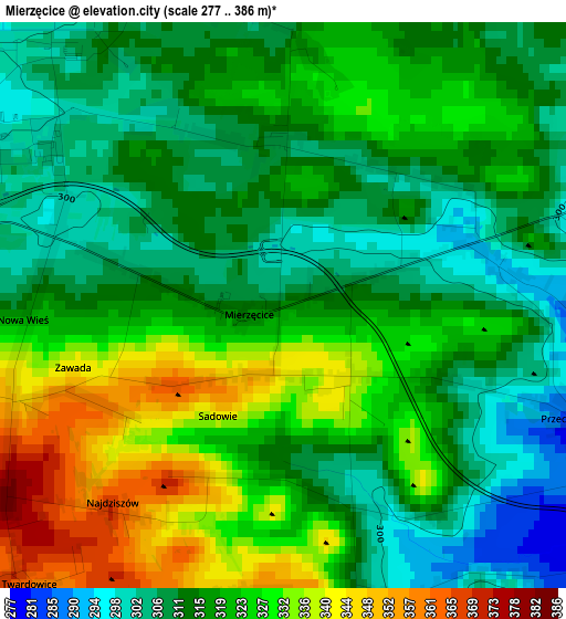
Below is the Elevation map of Mierzęcice, which displays elevation range with different colors. Scale of the first map is from 277 to 386 m (909 to 1266 ft) with average elevation of 318.8 meters (=1046 ft) [note 1]
These maps also provides idea of topography and contour of this city, they are displayed at different zoom levels. More info about maps, scale and edge coordinates you can find below images.
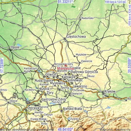
| \ | Map #1 | Topo.Map |
| Scale [m] | 277..386 m | × |
| Scale [ft] | 909..1266 ft | × |
| Average | 318.8 m = 1046 ft | × |
| Width | 6.22 km = 3.9 mi | 199.2 km = 123.8 mi |
| Height | 6.22 km = 3.9 mi | 199.1 km = 123.7 mi |
| ↑Max Latitude | 50.473017° | 51.33211° |
| Latitude at center | 50.44504° | 50.44504° |
| ↓Min Latitude | 50.417047° | 49.54102° |
| ← Min Longitude | 19.085395° | 17.72309° |
| Longitude center | 19.12934° | 19.12934° |
| →Max Longitude | 19.173285° | 20.53559° |
Nearby cities:
Cities around Mierzęcice sort by population:
• Będzin elevation 255 m
13.2 km,  181°
181°
• Wojkowice 289 m
11.1 km,  216°
216°
• Siewierz 299 m
7.5 km,  71°
71°
• Bobrowniki 279 m
12.4 km,  234°
234°
• Rogoźnik 301 m
8.8 km, 227°
• Psary 295 m
7.3 km,  187°
187°
• Dobieszowice 282 m
9.8 km,  237°
237°
• Sarnów 305 m
8.1 km,  169°
169°
• Strzyżowice 307 m
7.3 km,  208°
208°
• Ożarowice 292 m
6.4 km,  287°
287°
• Sączów 306 m
7.1 km,  261°
261°
• Cynków 362 m
13 km,  356°
356°
Multilingual:
 En español:
Mierzęcice elevación 316 m.
 En France:
Mierzęcice élévation 316 m.
 Auf Deutsch:
Mierzęcice höhe über dem Meeresspiegel ist 316 m.

Sources and notes:
- [note 1] Map square and city borders are not equal. Map elevation data is calculated only from area inside that square.
- [src 1] Elevation data from geonames database provided with same terms of usage.
- [src 2] The elevation map of Mierzęcice is generated using elevation data from NASA's 3 arcsec (90m) resolution SRTM data.
- [src 3] Base (background) map © OpenStreetMap contributors tiles are generated by Geofabrik and OpenTopoMap.
Copyright & License:
This Mierzęcice Elevation Map is licensed under CC BY-SA. You may reuse any part from this page, if you give a proper credit by linking to this URL:
 More info on terms of use page.