Nekla elevation
Nekla (Greater Poland, Powiat wrzesiński), Poland elevation is 113 meters and Nekla elevation in feet is 371 ft above sea level [src 1]. Nekla is a seat of a third-order administrative division (feature code) with elevation that is 78 meters (256 ft) smaller than average city elevation in Poland.
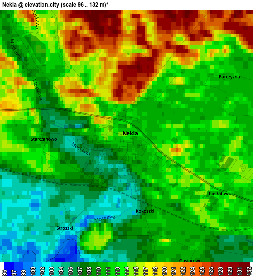
Below is the Elevation map of Nekla, which displays elevation range with different colors. Scale of the first map is from 96 to 132 m (315 to 433 ft) with average elevation of 112.6 meters (=369 ft) [note 1]
These maps also provides idea of topography and contour of this city, they are displayed at different zoom levels. More info about maps, scale and edge coordinates you can find below images.
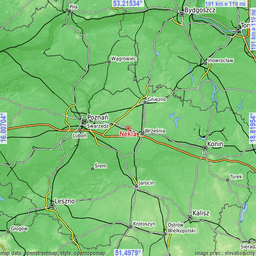
| \ | Map #1 | Topo.Map |
| Scale [m] | 96..132 m | × |
| Scale [ft] | 315..433 ft | × |
| Average | 112.6 m = 369 ft | × |
| Width | 5.97 km = 3.7 mi | 191 km = 118.7 mi |
| Height | 5.97 km = 3.7 mi | 190.9 km = 118.6 mi |
| ↑Max Latitude | 52.391786° | 53.21534° |
| Latitude at center | 52.36496° | 52.36496° |
| ↓Min Latitude | 52.338118° | 51.4979° |
| ← Min Longitude | 17.369345° | 16.00704° |
| Longitude center | 17.41329° | 17.41329° |
| →Max Longitude | 17.457235° | 18.81954° |
Nearby cities:
Cities around Nekla sort by population:
• Gniezno elevation 120 m
22.1 km,  31°
31°
• Września 106 m
11.2 km,  113°
113°
• Środa Wielkopolska 92 m
17.8 km,  211°
211°
• Kostrzyn 101 m
13.1 km,  286°
286°
• Pobiedziska 109 m
15.1 km,  325°
325°
• Miłosław 85 m
18.7 km,  163°
163°
• Czerniejewo 109 m
8.6 km,  37°
37°
• Niechanowo 121 m
21.1 km,  58°
58°
• Łubowo 115 m
16.5 km,  9°
9°
• Kołaczkowo 97 m
21.8 km,  138°
138°
• Kleszczewo 87 m
16.8 km,  258°
258°
• Dominowo 100 m
9 km,  204°
204°
Multilingual:
 En español:
Nekla elevación 113 m.
 En France:
Nekla élévation 113 m.


Sources and notes:
- [note 1] Map square and city borders are not equal. Map elevation data is calculated only from area inside that square.
- [src 1] Elevation data from geonames database provided with same terms of usage.
- [src 2] The elevation map of Nekla is generated using elevation data from NASA's 3 arcsec (90m) resolution SRTM data.
- [src 3] Base (background) map © OpenStreetMap contributors tiles are generated by Geofabrik and OpenTopoMap.
Copyright & License:
This Nekla Elevation Map is licensed under CC BY-SA. You may reuse any part from this page, if you give a proper credit by linking to this URL:
 More info on terms of use page.