Popów elevation
Popów (Silesia, Powiat kłobucki), Poland elevation is 214 meters and Popów elevation in feet is 702 ft above sea level [src 1]. Popów is a seat of a third-order administrative division (feature code) with elevation that is 23 meters (75 ft) bigger than average city elevation in Poland.
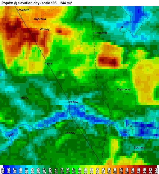
Below is the Elevation map of Popów, which displays elevation range with different colors. Scale of the first map is from 193 to 244 m (633 to 801 ft) with average elevation of 213.3 meters (=700 ft) [note 1]
These maps also provides idea of topography and contour of this city, they are displayed at different zoom levels. More info about maps, scale and edge coordinates you can find below images.
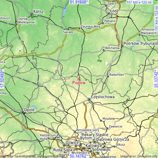
| \ | Map #1 | Topo.Map |
| Scale [m] | 193..244 m | × |
| Scale [ft] | 633..801 ft | × |
| Average | 213.3 m = 700 ft | × |
| Width | 6.14 km = 3.8 mi | 196.6 km = 122.2 mi |
| Height | 6.14 km = 3.8 mi | 196.6 km = 122.2 mi |
| ↑Max Latitude | 51.067913° | 51.91608° |
| Latitude at center | 51.04029° | 51.04029° |
| ↓Min Latitude | 51.01265° | 50.14762° |
| ← Min Longitude | 18.887225° | 17.52492° |
| Longitude center | 18.93117° | 18.93117° |
| →Max Longitude | 18.975115° | 20.33742° |
Nearby cities:
Cities around Popów sort by population:
• Kłobuck elevation 239 m
15.5 km,  178°
178°
• Pajęczno 222 m
12.4 km,  21°
21°
• Działoszyn 182 m
9.7 km,  331°
331°
• Krzepice 224 m
16.1 km,  241°
241°
• Miedzno 223 m
8.6 km,  155°
155°
• Ostrowy nad Okszą 208 m
11 km,  128°
128°
• Łobodno 222 m
12.9 km, 161°
• Kamyk 228 m
16.8 km, 156°
• Opatów 226 m
12.2 km,  219°
219°
• Lipie 221 m
9.9 km,  251°
251°
• Strzelce Wielkie 217 m
18.6 km,  53°
53°
• Siemkowice 190 m
18.1 km,  352°
352°
Multilingual:
 En español:
Popów elevación 214 m.
 En France:
Popów élévation 214 m.


Sources and notes:
- [note 1] Map square and city borders are not equal. Map elevation data is calculated only from area inside that square.
- [src 1] Elevation data from geonames database provided with same terms of usage.
- [src 2] The elevation map of Popów is generated using elevation data from NASA's 3 arcsec (90m) resolution SRTM data.
- [src 3] Base (background) map © OpenStreetMap contributors tiles are generated by Geofabrik and OpenTopoMap.
Copyright & License:
This Popów Elevation Map is licensed under CC BY-SA. You may reuse any part from this page, if you give a proper credit by linking to this URL:
 More info on terms of use page.