Rudawa elevation
Rudawa (Lesser Poland, Powiat krakowski), Poland elevation is 259 meters and Rudawa elevation in feet is 850 ft above sea level [src 1]. Rudawa is a populated place (feature code) with elevation that is 68 meters (223 ft) bigger than average city elevation in Poland.
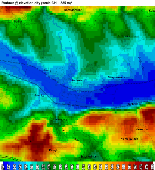
Below is the Elevation map of Rudawa, which displays elevation range with different colors. Scale of the first map is from 231 to 385 m (758 to 1263 ft) with average elevation of 285.7 meters (=937 ft) [note 1]
These maps also provides idea of topography and contour of this city, they are displayed at different zoom levels. More info about maps, scale and edge coordinates you can find below images.
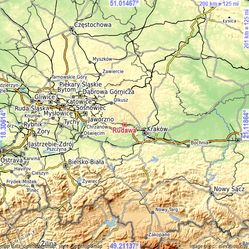
| \ | Map #1 | Topo.Map |
| Scale [m] | 231..385 m | × |
| Scale [ft] | 758..1263 ft | × |
| Average | 285.7 m = 937 ft | × |
| Width | 6.27 km = 3.9 mi | 200.5 km = 124.6 mi |
| Height | 6.27 km = 3.9 mi | 200.5 km = 124.6 mi |
| ↑Max Latitude | 50.149678° | 51.01467° |
| Latitude at center | 50.12151° | 50.12151° |
| ↓Min Latitude | 50.093326° | 49.21137° |
| ← Min Longitude | 19.668445° | 18.30614° |
| Longitude center | 19.71239° | 19.71239° |
| →Max Longitude | 19.756335° | 21.11864° |
Nearby cities:
Cities around Rudawa sort by population:
• Krzeszowice elevation 271 m
6.2 km,  292°
292°
• Zabierzów 246 m
6.1 km,  97°
97°
• Tenczynek 263 m
7.1 km,  268°
268°
• Zalas 351 m
7.9 km,  234°
234°
• Racławice 361 m
8.4 km,  342°
342°
• Bolechowice 281 m
6.5 km,  62°
62°
• Miękinia 360 m
8.3 km,  297°
297°
• Mników 229 m
6.9 km,  171°
171°
• Balice 251 m
6.9 km,  122°
122°
• Sanka 357 m
7.5 km,  218°
218°
• Czułów 278 m
6.9 km,  186°
186°
• Bębło 449 m
8.5 km,  39°
39°
Multilingual:
 En español:
Rudawa elevación 259 m.
 En France:
Rudawa élévation 259 m.


Sources and notes:
- [note 1] Map square and city borders are not equal. Map elevation data is calculated only from area inside that square.
- [src 1] Elevation data from geonames database provided with same terms of usage.
- [src 2] The elevation map of Rudawa is generated using elevation data from NASA's 3 arcsec (90m) resolution SRTM data.
- [src 3] Base (background) map © OpenStreetMap contributors tiles are generated by Geofabrik and OpenTopoMap.
Copyright & License:
This Rudawa Elevation Map is licensed under CC BY-SA. You may reuse any part from this page, if you give a proper credit by linking to this URL:
 More info on terms of use page.