Sopot elevation
Sopot (Pomerania), Poland elevation is 20 meters and Sopot elevation in feet is 66 ft above sea level [src 1]. Sopot is a populated place (feature code) with elevation that is 171 meters (561 ft) smaller than average city elevation in Poland.
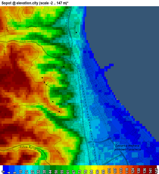
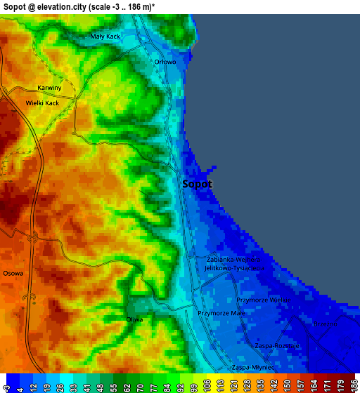
Below is the Elevation map of Sopot, which displays elevation range with different colors. Scale of the first map is from -2 to 147 m (-7 to 482 ft) with average elevation of 63.3 meters (=208 ft) [note 1]
These maps also provides idea of topography and contour of this city, they are displayed at different zoom levels. More info about maps, scale and edge coordinates you can find below images.
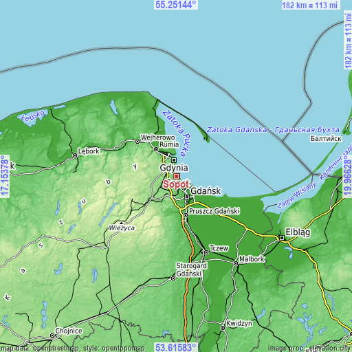
| \ | Map #1 | Map #2 | Topo.Map |
| Scale [m] | -2..147 m | -3..186 m | × |
| Scale [ft] | -7..482 ft | -10..610 ft | × |
| Average | 63.3 m = 208 ft | 81.6 m = 268 ft | × |
| Width | 5.68 km = 3.5 mi | 11.37 km = 7.1 mi | 181.9 km = 113 mi |
| Height | 5.68 km = 3.5 mi | 11.37 km = 7.1 mi | 181.8 km = 113 mi |
| ↑Max Latitude | 54.467348° | 54.492879° | 55.25144° |
| Latitude at center | 54.4418° | 54.4418° | 54.4418° |
| ↓Min Latitude | 54.416237° | 54.390657° | 53.61583° |
| ← Min Longitude | 18.516085° | 18.472139° | 17.15378° |
| Longitude center | 18.56003° | 18.56003° | 18.56003° |
| →Max Longitude | 18.603975° | 18.647921° | 19.96628° |
Nearby cities:
Cities around Sopot sort by population:
• Gdańsk elevation 7 m
11.4 km,  150°
150°
• Gdynia 14 m
8.8 km,  348°
348°
• Wielki Kack 134 m
5.5 km,  301°
301°
• Żukowo 132 m
16.8 km,  228°
228°
• Chwaszczyno 155 m
9.1 km,  271°
271°
• Banino 139 m
11.4 km,  240°
240°
• Bojano 161 m
11.8 km,  286°
286°
• Koleczkowo 151 m
14.8 km, 289°
• Kowale 87 m
14.7 km,  179°
179°
• Pogórze 77 m
14.5 km,  339°
339°
• Lublewo Gdańskie 79 m
17.9 km,  191°
191°
• Kosakowo 36 m
17.1 km, 343°
Multilingual:
 En español:
Sopot elevación 20 m.
 En France:
Sopot élévation 20 m.
 Auf Deutsch:
Zoppot, Sopot höhe über dem Meeresspiegel ist 20 m.

Sources and notes:
- [note 1] Map square and city borders are not equal. Map elevation data is calculated only from area inside that square.
- [src 1] Elevation data from geonames database provided with same terms of usage.
- [src 2] The elevation map of Sopot is generated using elevation data from NASA's 3 arcsec (90m) resolution SRTM data.
- [src 3] Base (background) map © OpenStreetMap contributors tiles are generated by Geofabrik and OpenTopoMap.
Copyright & License:
This Sopot Elevation Map is licensed under CC BY-SA. You may reuse any part from this page, if you give a proper credit by linking to this URL:
 More info on terms of use page.