Sopotnia Wielka elevation
Sopotnia Wielka (Silesia, Powiat żywiecki), Poland elevation is 738 meters and Sopotnia Wielka elevation in feet is 2421 ft above sea level [src 1]. Sopotnia Wielka is a populated place (feature code) with elevation that is 547 meters (1795 ft) bigger than average city elevation in Poland.
Below is the Elevation map of Sopotnia Wielka, which displays elevation range with different colors. Scale of the first map is from 563 to 1361 m (1847 to 4465 ft) with average elevation of 927.5 meters (=3043 ft) [note 1]
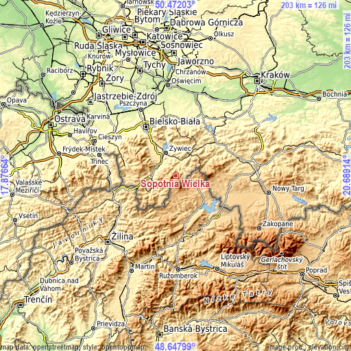
These maps also provides idea of topography and contour of this city, they are displayed at different zoom levels. More info about maps, scale and edge coordinates you can find below images.
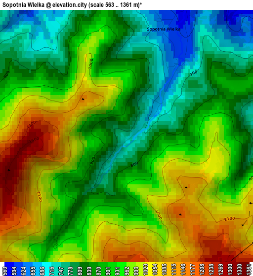
| \ | Map #1 | Topo.Map |
| Scale [m] | 563..1361 m | × |
| Scale [ft] | 1847..4465 ft | × |
| Average | 927.5 m = 3043 ft | × |
| Width | 6.34 km = 3.9 mi | 202.8 km = 126 mi |
| Height | 6.34 km = 3.9 mi | 202.8 km = 126 mi |
| ↑Max Latitude | 49.597022° | 50.47203° |
| Latitude at center | 49.56853° | 49.56853° |
| ↓Min Latitude | 49.540021° | 48.64799° |
| ← Min Longitude | 19.238945° | 17.87664° |
| Longitude center | 19.28289° | 19.28289° |
| →Max Longitude | 19.326835° | 20.68914° |
Nearby cities:
Cities around Sopotnia Wielka sort by population:
• Cięcina elevation 427 m
10.9 km,  290°
290°
• Węgierska Górka 408 m
12.8 km, 289°
• Jeleśnia 439 m
8.8 km,  21°
21°
• Wieprz 368 m
11.5 km,  319°
319°
• Żabnica 512 m
9.2 km,  278°
278°
• Koszarawa 571 m
12 km,  45°
45°
• Świnna 408 m
10.2 km,  348°
348°
• Przyborów 520 m
9.5 km, 51°
• Trzebinia 427 m
10.1 km,  334°
334°
• Juszczyna 474 m
8.2 km, 326°
• Krzyżowa 548 m
5.2 km,  59°
59°
• Korbielów 634 m
4.8 km,  90°
90°
Multilingual:
 En español:
Sopotnia Wielka elevación 738 m.
 En France:
Sopotnia Wielka élévation 738 m.
 Auf Deutsch:
Sopotnia Wielka höhe über dem Meeresspiegel ist 738 m.

Sources and notes:
- [note 1] Map square and city borders are not equal. Map elevation data is calculated only from area inside that square.
- [src 1] Elevation data from geonames database provided with same terms of usage.
- [src 2] The elevation map of Sopotnia Wielka is generated using elevation data from NASA's 3 arcsec (90m) resolution SRTM data.
- [src 3] Base (background) map © OpenStreetMap contributors tiles are generated by Geofabrik and OpenTopoMap.
Copyright & License:
This Sopotnia Wielka Elevation Map is licensed under CC BY-SA. You may reuse any part from this page, if you give a proper credit by linking to this URL:
 More info on terms of use page.