Suchy Dąb elevation
Suchy Dąb (Pomerania, Powiat gdański), Poland elevation is 1 meters and Suchy Dąb elevation in feet is 3 ft above sea level [src 1]. Suchy Dąb is a seat of a third-order administrative division (feature code) with elevation that is 190 meters (623 ft) smaller than average city elevation in Poland.
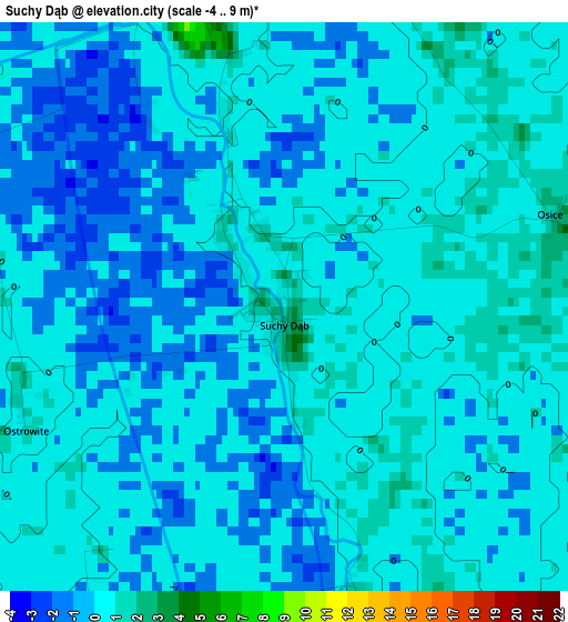
Below is the Elevation map of Suchy Dąb, which displays elevation range with different colors. Scale of the first map is from -4 to 9 m (-13 to 30 ft) with average elevation of -0.4 meters (=-1 ft) [note 1]
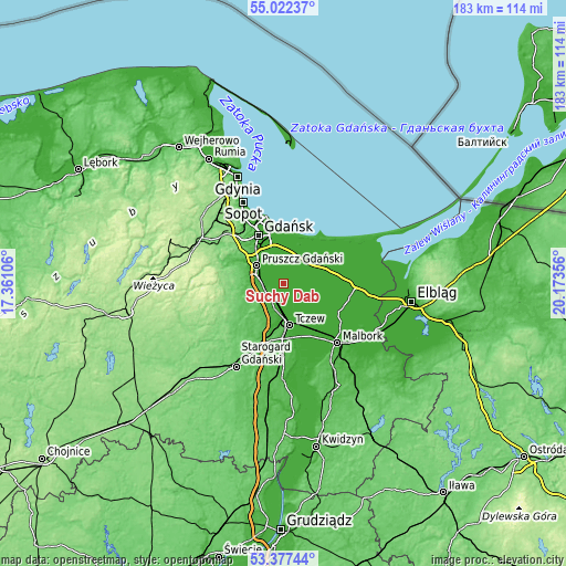
These maps also provides idea of topography and contour of this city, they are displayed at different zoom levels. More info about maps, scale and edge coordinates you can find below images.
| \ | Map #1 | Topo.Map |
| Scale [m] | -4..9 m | × |
| Scale [ft] | -13..30 ft | × |
| Average | -0.4 m = -1 ft | × |
| Width | 5.72 km = 3.6 mi | 182.9 km = 113.6 mi |
| Height | 5.72 km = 3.6 mi | 182.9 km = 113.6 mi |
| ↑Max Latitude | 54.233783° | 55.02237° |
| Latitude at center | 54.20809° | 54.20809° |
| ↓Min Latitude | 54.182381° | 53.37744° |
| ← Min Longitude | 18.723365° | 17.36106° |
| Longitude center | 18.76731° | 18.76731° |
| →Max Longitude | 18.811255° | 20.17356° |
Nearby cities:
Cities around Suchy Dąb sort by population:
• Tczew elevation 29 m
12.9 km,  176°
176°
• Pruszcz Gdański 12 m
10.4 km,  305°
305°
• Nowy Staw 7 m
17.7 km,  116°
116°
• Pszczółki 17 m
6 km,  229°
229°
• Straszyn 27 m
14 km,  300°
300°
• Łęgowo 13 m
8.3 km,  284°
284°
• Kowale 87 m
17.5 km, 310°
• Rotmanka 50 m
12.9 km, 304°
• Trąbki Wielkie 103 m
15.4 km,  254°
254°
• Lisewo Malborskie 5 m
13 km,  161°
161°
• Ostaszewo 3 m
12 km,  87°
87°
• Cedry Wielkie 0 m
6.7 km,  49°
49°
Multilingual:
 En español:
Suchy Dąb elevación 1 m.
 En France:
Suchy Dąb élévation 1 m.


Sources and notes:
- [note 1] Map square and city borders are not equal. Map elevation data is calculated only from area inside that square.
- [src 1] Elevation data from geonames database provided with same terms of usage.
- [src 2] The elevation map of Suchy Dąb is generated using elevation data from NASA's 3 arcsec (90m) resolution SRTM data.
- [src 3] Base (background) map © OpenStreetMap contributors tiles are generated by Geofabrik and OpenTopoMap.
Copyright & License:
This Suchy Dąb Elevation Map is licensed under CC BY-SA. You may reuse any part from this page, if you give a proper credit by linking to this URL:
 More info on terms of use page.