Trzebiatów elevation
Trzebiatów (West Pomerania, Powiat gryficki), Poland elevation is 18 meters and Trzebiatów elevation in feet is 59 ft above sea level [src 1]. Trzebiatów is a seat of a third-order administrative division (feature code) with elevation that is 173 meters (568 ft) smaller than average city elevation in Poland.
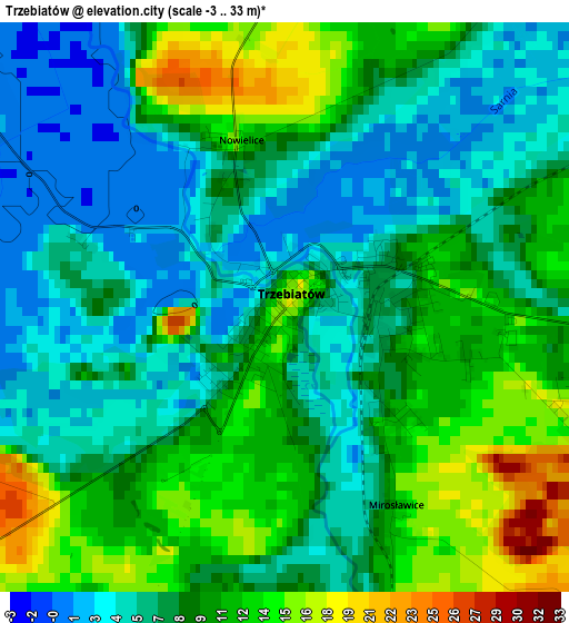
Below is the Elevation map of Trzebiatów, which displays elevation range with different colors. Scale of the first map is from -3 to 33 m (-10 to 108 ft) with average elevation of 8.5 meters (=28 ft) [note 1]
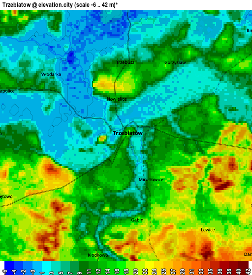
These maps also provides idea of topography and contour of this city, they are displayed at different zoom levels. More info about maps, scale and edge coordinates you can find below images.
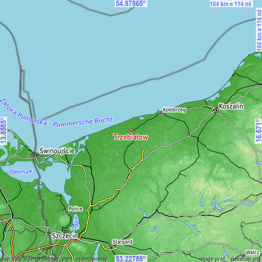
| \ | Map #1 | Map #2 | Topo.Map |
| Scale [m] | -3..33 m | -6..42 m | × |
| Scale [ft] | -10..108 ft | -20..138 ft | × |
| Average | 8.5 m = 28 ft | 11.5 m = 38 ft | × |
| Width | 5.74 km = 3.6 mi | 11.47 km = 7.1 mi | 183.5 km = 114 mi |
| Height | 5.74 km = 3.6 mi | 11.47 km = 7.1 mi | 183.5 km = 114 mi |
| ↑Max Latitude | 54.087254° | 54.113022° | 54.87865° |
| Latitude at center | 54.06147° | 54.06147° | 54.06147° |
| ↓Min Latitude | 54.03567° | 54.009853° | 53.22789° |
| ← Min Longitude | 15.220805° | 15.176859° | 13.8585° |
| Longitude center | 15.26475° | 15.26475° | 15.26475° |
| →Max Longitude | 15.308695° | 15.352641° | 16.671° |
Nearby cities:
Cities around Trzebiatów sort by population:
• Kołobrzeg elevation 6 m
24.3 km,  58°
58°
• Gryfice 17 m
16.7 km,  194°
194°
• Gościno 40 m
25.3 km,  92°
92°
• Mrzeżyno 2 m
9.3 km,  10°
10°
• Grzybowo 2 m
18 km,  53°
53°
• Cerkwica 20 m
11.8 km,  239°
239°
• Brojce 33 m
13.2 km,  151°
151°
• Rymań 52 m
21.6 km,  127°
127°
• Pobierowo 11 m
21.7 km,  269°
269°
• Rewal 16 m
16.5 km,  277°
277°
• Karnice 14 m
14.1 km,  255°
255°
• Świerzno 16 m
22.3 km, 241°
Multilingual:
 En español:
Trzebiatów elevación 18 m.
 En France:
Trzebiatów élévation 18 m.
 Auf Deutsch:
Trzebiatów höhe über dem Meeresspiegel ist 18 m.

Sources and notes:
- [note 1] Map square and city borders are not equal. Map elevation data is calculated only from area inside that square.
- [src 1] Elevation data from geonames database provided with same terms of usage.
- [src 2] The elevation map of Trzebiatów is generated using elevation data from NASA's 3 arcsec (90m) resolution SRTM data.
- [src 3] Base (background) map © OpenStreetMap contributors tiles are generated by Geofabrik and OpenTopoMap.
Copyright & License:
This Trzebiatów Elevation Map is licensed under CC BY-SA. You may reuse any part from this page, if you give a proper credit by linking to this URL:
 More info on terms of use page.