Władysławowo elevation
Władysławowo (Pomerania, Powiat pucki), Poland elevation is 19 meters and Władysławowo elevation in feet is 62 ft above sea level [src 1]. Władysławowo is a seat of a third-order administrative division (feature code) with elevation that is 172 meters (564 ft) smaller than average city elevation in Poland.
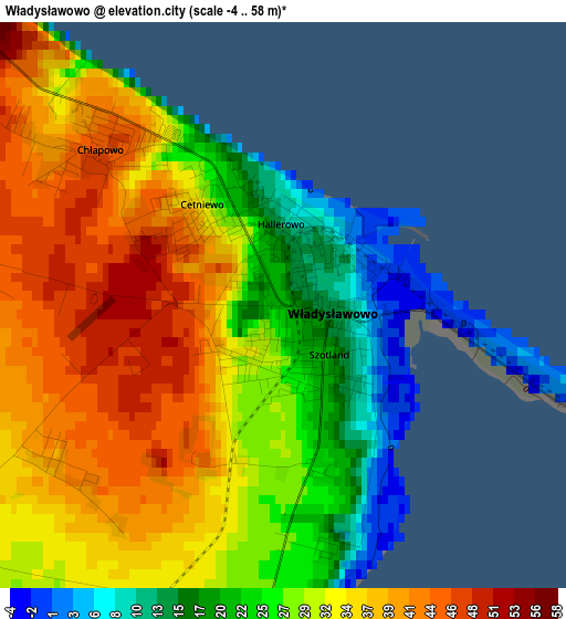
Below is the Elevation map of Władysławowo, which displays elevation range with different colors. Scale of the first map is from -4 to 58 m (-13 to 190 ft) with average elevation of 30.9 meters (=101 ft) [note 1]
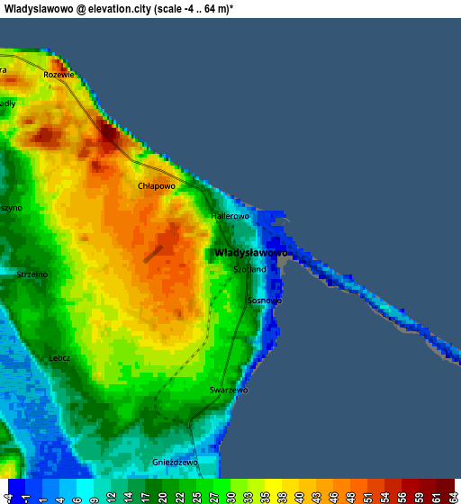
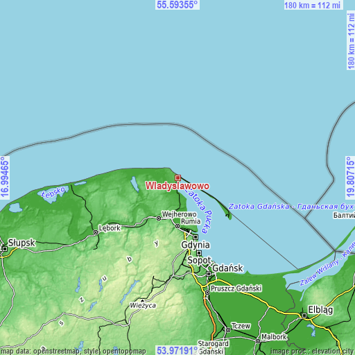
These maps also provides idea of topography and contour of this city, they are displayed at different zoom levels. More info about maps, scale and edge coordinates you can find below images.
| \ | Map #1 | Map #2 | Topo.Map |
| Scale [m] | -4..58 m | -4..64 m | × |
| Scale [ft] | -13..190 ft | -13..210 ft | × |
| Average | 30.9 m = 101 ft | 26.2 m = 86 ft | × |
| Width | 5.63 km = 3.5 mi | 11.27 km = 7 mi | 180.3 km = 112 mi |
| Height | 5.63 km = 3.5 mi | 11.27 km = 7 mi | 180.3 km = 112 mi |
| ↑Max Latitude | 54.816189° | 54.841503° | 55.59355° |
| Latitude at center | 54.79086° | 54.79086° | 54.79086° |
| ↓Min Latitude | 54.765515° | 54.740154° | 53.97191° |
| ← Min Longitude | 18.356955° | 18.313009° | 16.99465° |
| Longitude center | 18.4009° | 18.4009° | 18.4009° |
| →Max Longitude | 18.444845° | 18.488791° | 19.80715° |
Nearby cities:
Cities around Władysławowo sort by population:
• Reda elevation 7 m
20.9 km,  189°
189°
• Puck 14 m
8.1 km,  176°
176°
• Jastarnia 26 m
20.7 km,  120°
120°
• Żelistrzewo 25 m
12.6 km, 175°
• Mrzezino 46 m
15.4 km,  172°
172°
• Mosty 4 m
20.8 km,  162°
162°
• Rekowo Dolne 8 m
17.9 km, 187°
• Gnieżdżewo 13 m
5 km,  195°
195°
• Chłapowo 46 m
2.3 km,  309°
309°
• Jastrzębia Góra 33 m
7.2 km, 308°
• Strzelno 18 m
4.9 km,  263°
263°
• Krokowa 16 m
15.4 km,  265°
265°
Multilingual:
 En español:
Władysławowo elevación 19 m.
 En France:
Władysławowo élévation 19 m.
 Auf Deutsch:
Władysławowo höhe über dem Meeresspiegel ist 19 m.

Sources and notes:
- [note 1] Map square and city borders are not equal. Map elevation data is calculated only from area inside that square.
- [src 1] Elevation data from geonames database provided with same terms of usage.
- [src 2] The elevation map of Władysławowo is generated using elevation data from NASA's 3 arcsec (90m) resolution SRTM data.
- [src 3] Base (background) map © OpenStreetMap contributors tiles are generated by Geofabrik and OpenTopoMap.
Copyright & License:
This Władysławowo Elevation Map is licensed under CC BY-SA. You may reuse any part from this page, if you give a proper credit by linking to this URL:
 More info on terms of use page.