Wrząsowice elevation
Wrząsowice (Lesser Poland, Powiat krakowski), Poland elevation is 300 meters and Wrząsowice elevation in feet is 984 ft above sea level [src 1]. Wrząsowice is a populated place (feature code) with elevation that is 109 meters (358 ft) bigger than average city elevation in Poland.
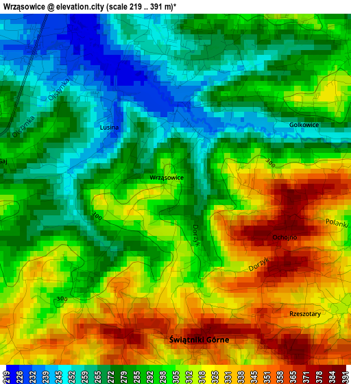
Below is the Elevation map of Wrząsowice, which displays elevation range with different colors. Scale of the first map is from 219 to 391 m (719 to 1283 ft) with average elevation of 297.2 meters (=975 ft) [note 1]
These maps also provides idea of topography and contour of this city, they are displayed at different zoom levels. More info about maps, scale and edge coordinates you can find below images.
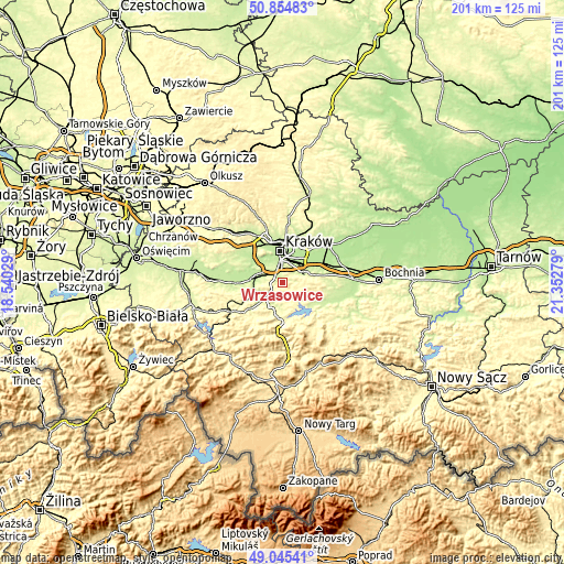
| \ | Map #1 | Topo.Map |
| Scale [m] | 219..391 m | × |
| Scale [ft] | 719..1283 ft | × |
| Average | 297.2 m = 975 ft | × |
| Width | 6.29 km = 3.9 mi | 201.2 km = 125 mi |
| Height | 6.29 km = 3.9 mi | 201.2 km = 125 mi |
| ↑Max Latitude | 49.986884° | 50.85483° |
| Latitude at center | 49.95862° | 49.95862° |
| ↓Min Latitude | 49.93034° | 49.04541° |
| ← Min Longitude | 19.902595° | 18.54029° |
| Longitude center | 19.94654° | 19.94654° |
| →Max Longitude | 19.990485° | 21.35279° |
Nearby cities:
Cities around Wrząsowice sort by population:
• Skawina elevation 218 m
8.6 km,  282°
282°
• Wieliczka 261 m
9 km,  69°
69°
• Siepraw 274 m
5 km,  170°
170°
• Głogoczów 237 m
8.8 km,  216°
216°
• Rzeszotary 384 m
2.3 km,  126°
126°
• Mogilany 358 m
4.6 km,  241°
241°
• Świątniki Górne 379 m
2.8 km, 169°
• Sidzina 231 m
6 km,  301°
301°
• Libertów 314 m
4 km,  292°
292°
• Krzyszkowice 251 m
8.5 km,  191°
191°
• Ochojno 387 m
2.1 km,  108°
108°
• Pawlikowice 341 m
7.8 km,  94°
94°
Multilingual:
 En español:
Wrząsowice elevación 300 m.
 En France:
Wrząsowice élévation 300 m.
 Auf Deutsch:
Wrząsowice höhe über dem Meeresspiegel ist 300 m.

Sources and notes:
- [note 1] Map square and city borders are not equal. Map elevation data is calculated only from area inside that square.
- [src 1] Elevation data from geonames database provided with same terms of usage.
- [src 2] The elevation map of Wrząsowice is generated using elevation data from NASA's 3 arcsec (90m) resolution SRTM data.
- [src 3] Base (background) map © OpenStreetMap contributors tiles are generated by Geofabrik and OpenTopoMap.
Copyright & License:
This Wrząsowice Elevation Map is licensed under CC BY-SA. You may reuse any part from this page, if you give a proper credit by linking to this URL:
 More info on terms of use page.