Bato Bato elevation
Bato Bato (Autonomous Region in Muslim Mindanao, Province of Sulu), Philippines elevation is 1 meters and Bato Bato elevation in feet is 3 ft above sea level [src 1]. Bato Bato is a populated place (feature code) with elevation that is 87 meters (285 ft) smaller than average city elevation in Philippines.
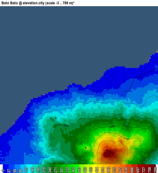
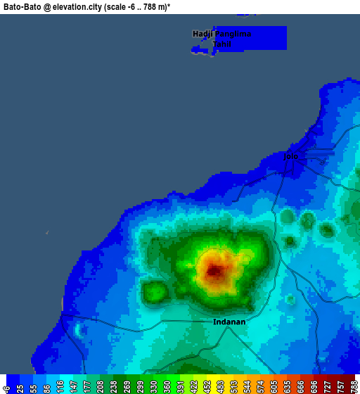
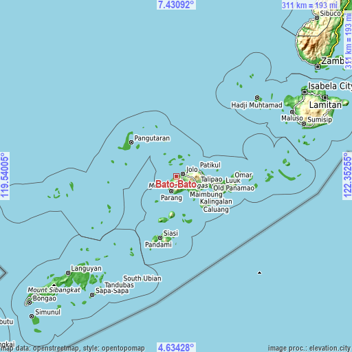
Below is the Elevation map of Bato Bato, which displays elevation range with different colors. Scale of the first map is from -3 to 788 m (-10 to 2585 ft) with average elevation of 181.6 meters (=596 ft) [note 1]
These maps also provides idea of topography and contour of this city, they are displayed at different zoom levels. More info about maps, scale and edge coordinates you can find below images.
| \ | Map #1 | Map #2 | Topo.Map |
| Scale [m] | -3..788 m | -6..788 m | × |
| Scale [ft] | -10..2585 ft | -20..2585 ft | × |
| Average | 181.6 m = 596 ft | 127.2 m = 417 ft | × |
| Width | 9.72 km = 6 mi | 19.44 km = 12.1 mi | 311 km = 193.2 mi |
| Height | 9.72 km = 6 mi | 19.44 km = 12.1 mi | 311 km = 193.2 mi |
| ↑Max Latitude | 6.0781° | 6.121797° | 7.43092° |
| Latitude at center | 6.0344° | 6.0344° | 6.0344° |
| ↓Min Latitude | 5.990696° | 5.946989° | 4.63428° |
| ← Min Longitude | 120.902355° | 120.858409° | 119.54005° |
| Longitude center | 120.9463° | 120.9463° | 120.9463° |
| →Max Longitude | 120.990245° | 121.034191° | 122.35255° |
Nearby cities:
Cities around Bato Bato sort by population:
• Jolo elevation 5 m
6.5 km,  72°
72°
• Anuling 54 m
6.7 km,  88°
88°
• Kajatian 82 m
5.1 km, 94°
• Payuhan 51 m
11.5 km,  205°
205°
• Bawison 10 m
13.4 km,  216°
216°
• Buansa 97 m
1.9 km,  119°
119°
• Sionogan 293 m
3.2 km,  175°
175°
• Panabuan 174 m
8.3 km,  167°
167°
• Langpas 176 m
6.6 km, 177°
• Kagay 12 m
5.2 km,  236°
236°
• Bangkal 59 m
13.8 km, 74°
• Baunu-Timbangan 155 m
6.2 km, 121°
Multilingual:
 En español:
Bato Bato elevación 1 m.
 En France:
Bato Bato élévation 1 m.


Sources and notes:
- [note 1] Map square and city borders are not equal. Map elevation data is calculated only from area inside that square.
- [src 1] Elevation data from geonames database provided with same terms of usage.
- [src 2] The elevation map of Bato Bato is generated using elevation data from NASA's 3 arcsec (90m) resolution SRTM data.
- [src 3] Base (background) map © OpenStreetMap contributors tiles are generated by Geofabrik and OpenTopoMap.
Copyright & License:
This Bato Bato Elevation Map is licensed under CC BY-SA. You may reuse any part from this page, if you give a proper credit by linking to this URL:
 More info on terms of use page.