Talipaw elevation
Talipaw (Autonomous Region in Muslim Mindanao, Province of Sulu), Philippines elevation is 20 meters and Talipaw elevation in feet is 66 ft above sea level [src 1]. Talipaw is a populated place (feature code) with elevation that is 68 meters (223 ft) smaller than average city elevation in Philippines.
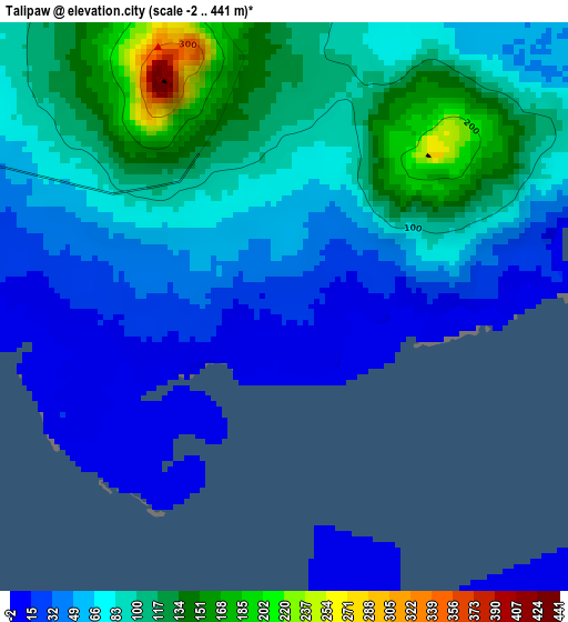
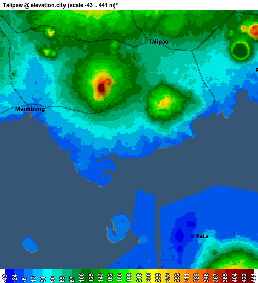
Below is the Elevation map of Talipaw, which displays elevation range with different colors. Scale of the first map is from -2 to 441 m (-7 to 1447 ft) with average elevation of 75 meters (=246 ft) [note 1]
These maps also provides idea of topography and contour of this city, they are displayed at different zoom levels. More info about maps, scale and edge coordinates you can find below images.
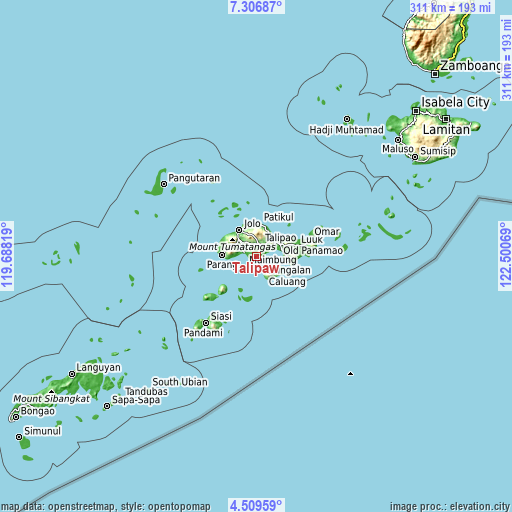
| \ | Map #1 | Map #2 | Topo.Map |
| Scale [m] | -2..441 m | -43..441 m | × |
| Scale [ft] | -7..1447 ft | -141..1447 ft | × |
| Average | 75 m = 246 ft | 69.7 m = 229 ft | × |
| Width | 9.72 km = 6 mi | 19.44 km = 12.1 mi | 311 km = 193.2 mi |
| Height | 9.72 km = 6 mi | 19.44 km = 12.1 mi | 311.1 km = 193.3 mi |
| ↑Max Latitude | 5.95371° | 5.997417° | 7.30687° |
| Latitude at center | 5.91° | 5.91° | 5.91° |
| ↓Min Latitude | 5.866287° | 5.82257° | 4.50959° |
| ← Min Longitude | 121.050495° | 121.006549° | 119.68819° |
| Longitude center | 121.09444° | 121.09444° | 121.09444° |
| →Max Longitude | 121.138385° | 121.182331° | 122.50069° |
Nearby cities:
Cities around Talipaw sort by population:
• Kulase elevation 39 m
15.2 km,  267°
267°
• Punay 28 m
12.8 km,  63°
63°
• Maimbung 8 m
8.1 km,  288°
288°
• Pandakan 122 m
11.8 km,  41°
41°
• Binuang 127 m
6.5 km,  323°
323°
• Tunggol 5 m
9.8 km,  137°
137°
• Marsada 113 m
2.8 km,  30°
30°
• Mauboh 162 m
8.9 km,  359°
359°
• Mahala 22 m
4.4 km,  80°
80°
• Baunu-Timbangan 155 m
15.4 km,  313°
313°
• New Panamao 6 m
12.5 km,  69°
69°
• Talipao 81 m
7.8 km,  17°
17°
Multilingual:
 En español:
Talipaw elevación 20 m.
 En France:
Talipaw élévation 20 m.


Sources and notes:
- [note 1] Map square and city borders are not equal. Map elevation data is calculated only from area inside that square.
- [src 1] Elevation data from geonames database provided with same terms of usage.
- [src 2] The elevation map of Talipaw is generated using elevation data from NASA's 3 arcsec (90m) resolution SRTM data.
- [src 3] Base (background) map © OpenStreetMap contributors tiles are generated by Geofabrik and OpenTopoMap.
Copyright & License:
This Talipaw Elevation Map is licensed under CC BY-SA. You may reuse any part from this page, if you give a proper credit by linking to this URL:
 More info on terms of use page.