Aliaga elevation
Aliaga (Central Luzon, Province of Nueva Ecija), Philippines elevation is 28 meters and Aliaga elevation in feet is 92 ft above sea level [src 1]. Aliaga is a seat of a third-order administrative division (feature code) with elevation that is 60 meters (197 ft) smaller than average city elevation in Philippines.
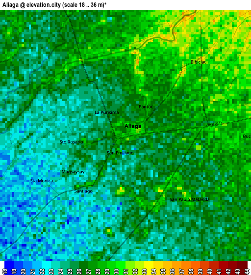
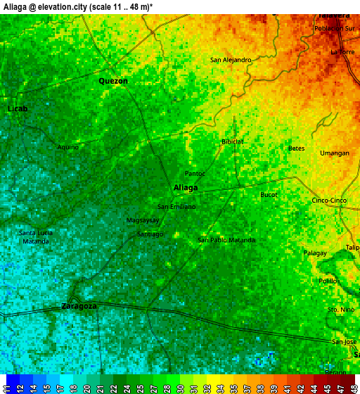
Below is the Elevation map of Aliaga, which displays elevation range with different colors. Scale of the first map is from 18 to 36 m (59 to 118 ft) with average elevation of 25.7 meters (=84 ft) [note 1]
These maps also provides idea of topography and contour of this city, they are displayed at different zoom levels. More info about maps, scale and edge coordinates you can find below images.
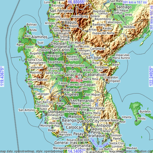
| \ | Map #1 | Map #2 | Topo.Map |
| Scale [m] | 18..36 m | 11..48 m | × |
| Scale [ft] | 59..118 ft | 36..157 ft | × |
| Average | 25.7 m = 84 ft | 26.8 m = 88 ft | × |
| Width | 9.42 km = 5.9 mi | 18.83 km = 11.7 mi | 301.3 km = 187.2 mi |
| Height | 9.42 km = 5.9 mi | 18.83 km = 11.7 mi | 301.3 km = 187.2 mi |
| ↑Max Latitude | 15.542343° | 15.584677° | 16.85055° |
| Latitude at center | 15.5° | 15.5° | 15.5° |
| ↓Min Latitude | 15.457649° | 15.415289° | 14.14057° |
| ← Min Longitude | 120.799055° | 120.755109° | 119.43675° |
| Longitude center | 120.843° | 120.843° | 120.843° |
| →Max Longitude | 120.886945° | 120.930891° | 122.24925° |
Nearby cities:
Cities around Aliaga sort by population:
• Quezon elevation 29 m
6.4 km,  331°
331°
• Rajal Norte 27 m
6.5 km,  161°
161°
• Bibiclat 33 m
3.2 km,  40°
40°
• Santo Rosario 27 m
8.9 km,  145°
145°
• Concepcion 22 m
7.7 km,  216°
216°
• Santa Lucia 23 m
7.6 km,  254°
254°
• Santa Maria 27 m
6 km,  295°
295°
• San Felipe Old 32 m
6.9 km,  88°
88°
• San Alejandro 33 m
6.8 km,  5°
5°
• Carmen 25 m
6.1 km,  196°
196°
• San Casimiro 28 m
8.9 km,  311°
311°
• San Carlos 37 m
7.3 km,  47°
47°
Multilingual:
 En español:
Aliaga elevación 28 m.
 En France:
Aliaga élévation 28 m.


Sources and notes:
- [note 1] Map square and city borders are not equal. Map elevation data is calculated only from area inside that square.
- [src 1] Elevation data from geonames database provided with same terms of usage.
- [src 2] The elevation map of Aliaga is generated using elevation data from NASA's 3 arcsec (90m) resolution SRTM data.
- [src 3] Base (background) map © OpenStreetMap contributors tiles are generated by Geofabrik and OpenTopoMap.
Copyright & License:
This Aliaga Elevation Map is licensed under CC BY-SA. You may reuse any part from this page, if you give a proper credit by linking to this URL:
 More info on terms of use page.