Ani-e elevation
Ani-e (Northern Mindanao, Province of Misamis Oriental), Philippines elevation is 536 meters and Ani-e elevation in feet is 1759 ft above sea level [src 1]. Ani-e is a populated place (feature code) with elevation that is 448 meters (1470 ft) bigger than average city elevation in Philippines.
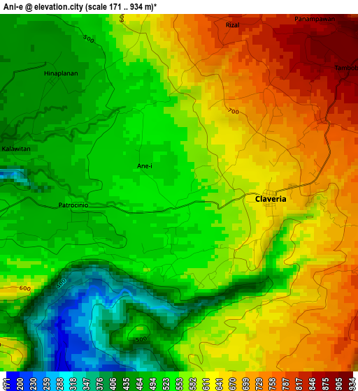
Below is the Elevation map of Ani-e, which displays elevation range with different colors. Scale of the first map is from 171 to 934 m (561 to 3064 ft) with average elevation of 573.1 meters (=1880 ft) [note 1]
These maps also provides idea of topography and contour of this city, they are displayed at different zoom levels. More info about maps, scale and edge coordinates you can find below images.
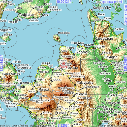
| \ | Map #1 | Topo.Map |
| Scale [m] | 171..934 m | × |
| Scale [ft] | 561..3064 ft | × |
| Average | 573.1 m = 1880 ft | × |
| Width | 9.66 km = 6 mi | 309.2 km = 192.1 mi |
| Height | 9.66 km = 6 mi | 309.2 km = 192.1 mi |
| ↑Max Latitude | 8.657057° | 10.00131° |
| Latitude at center | 8.61361° | 8.61361° |
| ↓Min Latitude | 8.570158° | 7.2208° |
| ← Min Longitude | 124.826615° | 123.46431° |
| Longitude center | 124.87056° | 124.87056° |
| →Max Longitude | 124.914505° | 126.27681° |
Nearby cities:
Cities around Ani-e sort by population:
• Jasaan elevation 31 m
13.4 km,  289°
289°
• Claveria 655 m
2.7 km,  98°
98°
• Villanueva 10 m
10.8 km,  255°
255°
• Santa Ana 57 m
14.4 km,  221°
221°
• Kimaya 181 m
6.4 km,  211°
211°
• Aplaya 42 m
11.3 km,  267°
267°
• San Martin 13 m
12.4 km,  241°
241°
• Patrocinio 484 m
2.8 km, 267°
• Malitbog 150 m
9 km,  171°
171°
• Solana 134 m
11 km,  275°
275°
• Baliwagan 0 m
14.6 km,  323°
323°
• Hinapalanan 656 m
3 km,  5°
5°
Multilingual:
 En español:
Ani-e elevación 536 m.
 En France:
Ani-e élévation 536 m.


Sources and notes:
- [note 1] Map square and city borders are not equal. Map elevation data is calculated only from area inside that square.
- [src 1] Elevation data from geonames database provided with same terms of usage.
- [src 2] The elevation map of Ani-e is generated using elevation data from NASA's 3 arcsec (90m) resolution SRTM data.
- [src 3] Base (background) map © OpenStreetMap contributors tiles are generated by Geofabrik and OpenTopoMap.
Copyright & License:
This Ani-e Elevation Map is licensed under CC BY-SA. You may reuse any part from this page, if you give a proper credit by linking to this URL:
 More info on terms of use page.